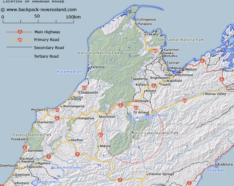
Map showing location of Mahanga Range


LINZ description: Range of peaks extending from Mount Mahanga in the Spenser Mountains, running northward through Moss Pass and Mount Windward to Mount Misery [Trig. P (Geodetic Code A5AQ)]. Rotoroa and Sabine Survey Districts.
Latitude: -42.019306
Longitude: 172.64344
Northing: 5348018.8
Easting: 1570479.5
Land District: Nelson
Feat Type: Range


Scroll down to see a more detailed road map and below that a topographical map showing the location of Mahanga Range. The road map has been supplied by openstreetmap and the topographical map of Mahanga Range has been supplied by Land Information New Zealand (LINZ).

Yes you can use the top static map for you school/university project or personal website with a link back. Contact me for any commercial use.

Mahanga Range Map New Zealand


New Zealand places in our database
[ A ] [ B ] [ C ] [ D ] [ E ] [ F ] [ G ] [ H ] [ I ] [ J ] [ K ] [ L ] [ M ] [ N ] [ O ] [ P ] [ Q ] [ R ] [ S ] [ T ] [ U ] [ V ] [ W ] [ X ] [ Y ] [ Z ]


Closest 20 Ranges to Mahanga Range

Mahanga Range ( 0km )   St Arnaud Range ( 8.91km )   Ella Range ( 9.23km )   Travers Range ( 15.18km )   Muntz Range ( 21.28km )   The Dreadnought ( 28.17km )   Braeburn Range ( 30.35km )   Crimea Range ( 30.36km )   Raglan Range ( 30.99km )   Spenser Range ( 35.43km )   Boddington Range ( 36.14km )   St James Range ( 37.7km )   Opera Range ( 41.64km )   Freyberg Range ( 41.86km )   Rachel Range ( 43.29km )   Hope Range ( 44.62km )   Victoria Range ( 45.72km )   Libretto Range ( 49.34km )   Pinchback Range ( 51.15km )   Brunner Range ( 51.4km )   Lyell Range ( 52.37km )   Matiri Range ( 53.1km )   Gordon Range ( 53.33km )   Hanmer Range ( 54.55km )   Lookout Range ( 55.3km )   Sylvia Tops ( 56.83km )   Poplars Range ( 58.65km )   Amuri Range ( 62.49km )   Spooners Range ( 65.09km )   Glasgow Range ( 65.69km )   Allen Range ( 67.62km )   Doubtful Range ( 68.21km )   Dog Hills ( 68.74km )   Richmond Range ( 68.93km )   Inland Kaikoura Range ( 69.18km )   Gridiron Hills ( 69.72km )   Old Man Hills ( 69.89km )   Spray Hills ( 70.37km )   Tekoa Range ( 71.46km )   Culverden Range ( 71.76km )