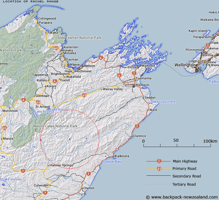
Map showing location of Rachel Range


LINZ description: Mountain Range approximately 17 miles in length, extending from Saxton Pass in Marlborough Land District to junction of Guide and Acheron Rivers in Canterbury Land District
Latitude: -42.192011
Longitude: 173.113664
Northing: 5328898.4
Easting: 1609385.1
Land District: Marlborough, Nelson, Canterbury
Feat Type: Range


Scroll down to see a more detailed road map and below that a topographical map showing the location of Rachel Range. The road map has been supplied by openstreetmap and the topographical map of Rachel Range has been supplied by Land Information New Zealand (LINZ).

Yes you can use the top static map for you school/university project or personal website with a link back. Contact me for any commercial use.

Rachel Range Map New Zealand


New Zealand places in our database
[ A ] [ B ] [ C ] [ D ] [ E ] [ F ] [ G ] [ H ] [ I ] [ J ] [ K ] [ L ] [ M ] [ N ] [ O ] [ P ] [ Q ] [ R ] [ S ] [ T ] [ U ] [ V ] [ W ] [ X ] [ Y ] [ Z ]


Closest 20 Ranges to Rachel Range

Boddington Range ( 15.25km )   Crimea Range ( 23.4km )   Amuri Range ( 26.9km )   Gridiron Hills ( 26.93km )   Dog Hills ( 27.77km )   Spray Hills ( 29.88km )   Hawk Range ( 30.42km )   Inland Kaikoura Range ( 30.75km )   St Arnaud Range ( 34.44km )   Raglan Range ( 36.7km )   St James Range ( 36.76km )   Old Man Hills ( 37.94km )   Hanmer Range ( 38.62km )   Black Hills ( 39.03km )   Mahanga Range ( 43.29km )   The Humps ( 45.09km )   Travers Range ( 45.14km )   Ella Range ( 46.39km )   Schooner Range ( 46.74km )   Haycock Range ( 47.3km )   Junction Range ( 47.42km )   Front Grey Hills ( 48.01km )   Seaward Kaikoura Range ( 48.84km )   Red Hills ( 50.04km )   Back Grey Hills ( 50.17km )   Spenser Range ( 55.22km )   Muntz Range ( 55.37km )   Hawkswood Range ( 55.86km )   Opera Range ( 57.13km )   Culverden Range ( 61.77km )   Libretto Range ( 61.96km )   Freyberg Range ( 63.19km )   Poplars Range ( 65.63km )   Tekoa Range ( 65.81km )   Lowry Peaks Range ( 66.8km )   Gordon Range ( 66.94km )   The Dreadnought ( 67.36km )   Braeburn Range ( 67.55km )   Sawtooth Range ( 70.75km )   Sylvia Tops ( 71.03km )