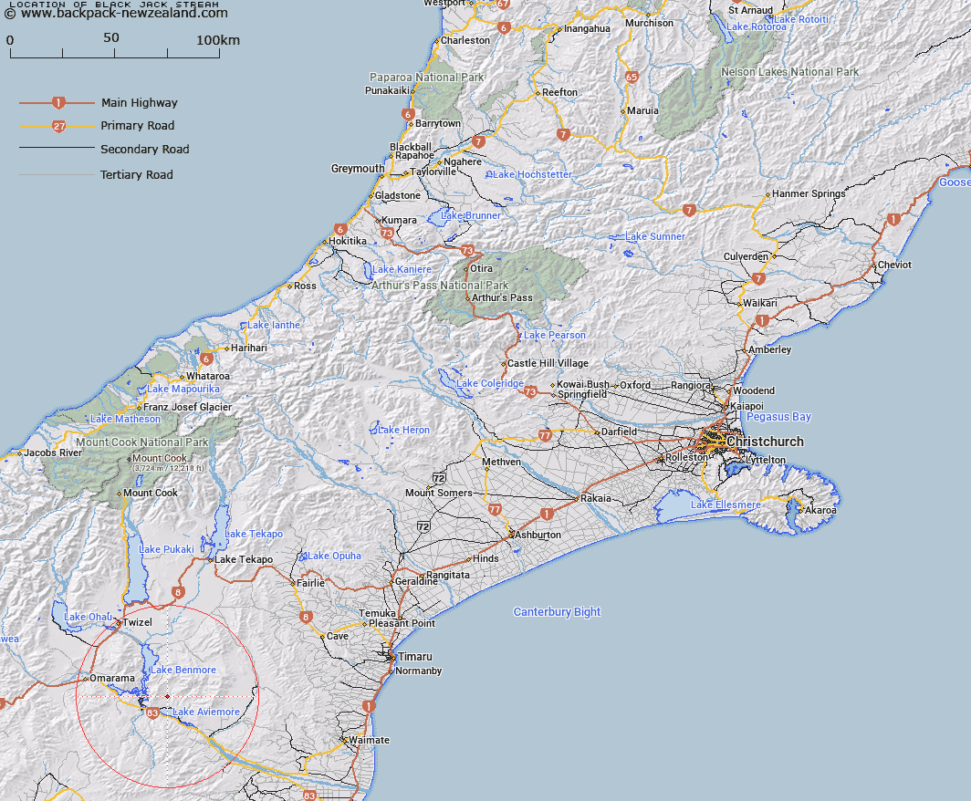
Map showing location of Black Jack Stream


LINZ description: A tributary of Gibson Stream flowing into Lake Aviemore, north of the Aviemore Dam.
Latitude: -44.552502
Longitude: 170.302387
Northing: 5063219
Easting: 1385737
Land District: Canterbury
Feat Type: Stream


Scroll down to see a more detailed road map and below that a topographical map showing the location of Black Jack Stream. The road map has been supplied by openstreetmap and the topographical map of Black Jack Stream has been supplied by Land Information New Zealand (LINZ).

Yes you can use the top static map for you school/university project or personal website with a link back. Contact me for any commercial use.

Black Jack Stream Map New Zealand


New Zealand places in our database
[ A ] [ B ] [ C ] [ D ] [ E ] [ F ] [ G ] [ H ] [ I ] [ J ] [ K ] [ L ] [ M ] [ N ] [ O ] [ P ] [ Q ] [ R ] [ S ] [ T ] [ U ] [ V ] [ W ] [ X ] [ Y ] [ Z ]


Closest 20 Streams to Black Jack Stream

Sutton Stream ( 1.42km )   Gibson Stream ( 1.8km )   Miller Stream ( 2.51km )   Douglas Stream ( 4.78km )   Stony Stream ( 5.34km )   Whalan Stream ( 5.71km )   Te Akatarewa Stream ( 6.01km )   Glen Begg Stream ( 8.19km )   Fraser Stream ( 10.58km )   Banks Stream ( 10.84km )   Dry Stream ( 10.92km )   Deep Stream ( 10.93km )   Macleod Stream ( 11.26km )   Boundary Stream ( 11.32km )   Rattray Stream ( 11.36km )   Baker Creek ( 11.66km )   Coal Stream ( 12.07km )   Coal Creek ( 12.39km )   Rugged Ridges Creek ( 12.56km )   Staircase Stream ( 12.56km )   McRae Creek ( 12.6km )   Black Forest Stream ( 12.88km )   Innes Burn ( 13.41km )   Peak Valley Creek ( 14.36km )   Parsons Rock Creek ( 14.86km )   Station Creek ( 14.93km )   Fern Gully Creek ( 15.09km )   Shepherds Creek ( 15.4km )   Wharekuri Creek ( 15.96km )   Basin Stream ( 16.03km )   Otamatapaio River ( 16.93km )   Hemphill Creek ( 17.39km )   Clark Creek ( 17.43km )   Ross Stream ( 18.06km )   Awahokomo Creek ( 18.46km )   Preston Stream ( 18.52km )   Potato Creek ( 18.6km )   Totara Creek ( 18.98km )   Glen Creek ( 19.9km )   Hay Stream ( 19.98km )