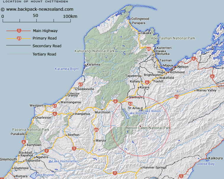
Map showing location of Mount Chittenden


LINZ description: The mountain peak on Fifteen Mile Spur east of St Arnaud Range.
Latitude: -42.008639
Longitude: 172.820615
Northing: 5349249.1
Easting: 1585145.8
Land District: Nelson
Feat Type: Hill


Scroll down to see a more detailed road map and below that a topographical map showing the location of Mount Chittenden. The road map has been supplied by openstreetmap and the topographical map of Mount Chittenden has been supplied by Land Information New Zealand (LINZ).

Yes you can use the top static map for you school/university project or personal website with a link back. Contact me for any commercial use.

Mount Chittenden Map New Zealand


New Zealand places in our database
[ A ] [ B ] [ C ] [ D ] [ E ] [ F ] [ G ] [ H ] [ I ] [ J ] [ K ] [ L ] [ M ] [ N ] [ O ] [ P ] [ Q ] [ R ] [ S ] [ T ] [ U ] [ V ] [ W ] [ X ] [ Y ] [ Z ]


Closest 20 Hills to Mount Chittenden

Mount Chittenden ( 0km )   Cotterell Peak ( 2.91km )   Mount Cashel ( 5.13km )   Spaniard Face ( 5.31km )   The Camel ( 6.1km )   Kehu Peak ( 6.16km )   Mount Travers ( 7.09km )   Stockyard Face ( 7.36km )   Elise Peak ( 8.57km )   Mount Cupola ( 8.72km )   Turk Mountain ( 9.32km )   Mount Hopeless ( 9.52km )   Mount Iris ( 9.75km )   Mount Weld ( 10.35km )   Mount McKay ( 10.74km )   Mount Paske ( 11.09km )   Peanter Peak ( 11.29km )   Mount Franklin ( 11.97km )   Maniniaro / Angelus Peak ( 12.91km )   Angelus Peak ( 12.91km )   Windward Peak ( 13.13km )   Belvedere Peak ( 13.39km )   Mount McRae ( 14.24km )   Mount Misery ( 15.12km )   Mount Cedric ( 15.51km )   Mount Dora ( 16.14km )   Julius Peak ( 16.52km )   Mount Guinevere ( 16.94km )   Flagtop ( 17.64km )   Mount Tarndale ( 17.83km )   Mount Mahanga ( 18.5km )   Mount Balaclava ( 18.75km )   Crystal Peak ( 19.09km )   Mount Maling ( 19.13km )   Alma Peak ( 19.4km )   Pourangahau / Mount Robert ( 19.62km )   Mount Robert ( 19.62km )   Alma Heights ( 19.85km )   Mount Hutton ( 19.94km )   Mount Watson ( 20.32km )