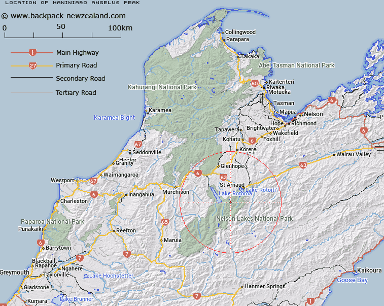
Map showing location of Maniniaro / Angelus Peak


LINZ description: A hill at 2075 m at the western end of Angelus Ridge in Travers Range approximately 7.5km southwest of Lake Rotoiti. NZTopo50-BS24 788604.
Latitude: -41.907586
Longitude: 172.743844
Northing: 5360452.6
Easting: 1578755.1
Land District: Nelson
Feat Type: Hill


Scroll down to see a more detailed road map and below that a topographical map showing the location of Maniniaro / Angelus Peak. The road map has been supplied by openstreetmap and the topographical map of Maniniaro / Angelus Peak has been supplied by Land Information New Zealand (LINZ).

Yes you can use the top static map for you school/university project or personal website with a link back. Contact me for any commercial use.

Maniniaro / Angelus Peak Map New Zealand


New Zealand places in our database
[ A ] [ B ] [ C ] [ D ] [ E ] [ F ] [ G ] [ H ] [ I ] [ J ] [ K ] [ L ] [ M ] [ N ] [ O ] [ P ] [ Q ] [ R ] [ S ] [ T ] [ U ] [ V ] [ W ] [ X ] [ Y ] [ Z ]


Closest 20 Hills to Maniniaro / Angelus Peak

Mount Cedric ( 3.05km )   Mount Hopeless ( 4.49km )   Julius Peak ( 5.51km )   Mount Misery ( 6.93km )   Flagtop ( 7.09km )   Peanter Peak ( 7.45km )   The Camel ( 8.04km )   Mount Cupola ( 8.83km )   Mount McRae ( 8.9km )   Mount Robert ( 10.06km )   Pourangahau / Mount Robert ( 10.06km )   Mount Hutton ( 10.07km )   Cotterell Peak ( 10.21km )   Mount Travers ( 11.8km )   Playfair ( 12.22km )   Windward Peak ( 12.43km )   Mount Chittenden ( 12.91km )   Kehu Peak ( 14.2km )   Black Hill ( 14.4km )   Spaniard Face ( 14.76km )   Mole Tops ( 15.29km )   Mount Pickering ( 15.5km )   Mount Franklin ( 16.67km )   Elise Peak ( 16.75km )   Mount Cashel ( 17.03km )   Mount Watson ( 17.88km )   Burnt Spur ( 18.14km )   Three Peaks ( 18.22km )   Mount Cotton ( 18.45km )   Stockyard Face ( 18.57km )   Mount McKay ( 18.66km )   Twins ( 19.8km )   Mount Paske ( 20.22km )   Porika Knob ( 20.59km )   Mount Baring ( 21.56km )   Mount Iris ( 21.6km )   Belvedere Peak ( 21.88km )   Thomson ( 22.05km )   Turk Mountain ( 22.13km )   Mount Weld ( 23.1km )