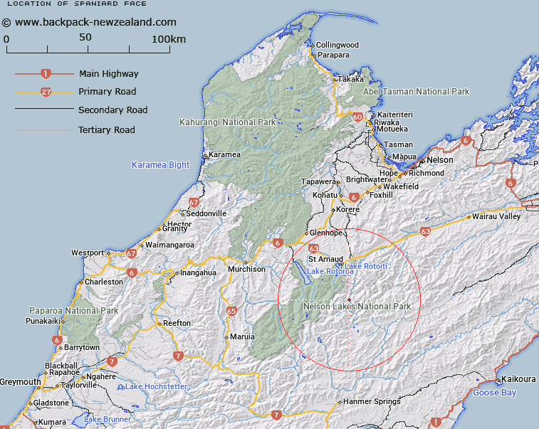
Map showing location of Spaniard Face


LINZ description: A hill face area on western side of Wairau River, South-west of the Old Rainbow Homestead, between Shroders and Connors Creeks. Block XIV Rotoiti and Block IV Rainbow Survey Districts.
Latitude: -41.992465
Longitude: 172.881027
Northing: 5351053.6
Easting: 1590145.8
Land District: Nelson
Feat Type: Hill


Scroll down to see a more detailed road map and below that a topographical map showing the location of Spaniard Face. The road map has been supplied by openstreetmap and the topographical map of Spaniard Face has been supplied by Land Information New Zealand (LINZ).

Yes you can use the top static map for you school/university project or personal website with a link back. Contact me for any commercial use.

Spaniard Face Map New Zealand


New Zealand places in our database
[ A ] [ B ] [ C ] [ D ] [ E ] [ F ] [ G ] [ H ] [ I ] [ J ] [ K ] [ L ] [ M ] [ N ] [ O ] [ P ] [ Q ] [ R ] [ S ] [ T ] [ U ] [ V ] [ W ] [ X ] [ Y ] [ Z ]


Closest 20 Hills to Spaniard Face

Elise Peak ( 3.26km )   Mount Cashel ( 3.36km )   Stockyard Face ( 3.93km )   Mount Chittenden ( 5.31km )   The Camel ( 6.72km )   Cotterell Peak ( 7.2km )   Turk Mountain ( 8.99km )   Peanter Peak ( 10.21km )   Kehu Peak ( 11.43km )   Mount Weld ( 11.93km )   Mount Travers ( 12.28km )   Mount McRae ( 12.63km )   Mount Hopeless ( 12.71km )   Mount Iris ( 12.97km )   Mount Cupola ( 13.34km )   Angelus Peak ( 14.76km )   Maniniaro / Angelus Peak ( 14.76km )   Mount McKay ( 15.75km )   Mount Paske ( 15.76km )   Julius Peak ( 16.76km )   Mount Franklin ( 17.27km )   Flagtop ( 17.47km )   Mount Cedric ( 17.73km )   Severn ( 18.08km )   Belvedere Peak ( 18.1km )   Windward Peak ( 18.13km )   Alma Peak ( 18.33km )   Alma Heights ( 18.68km )   Mount Tarndale ( 18.71km )   Mount Robert ( 18.72km )   Pourangahau / Mount Robert ( 18.72km )   Mount Misery ( 18.79km )   Mount Dora ( 20.44km )   Mount Balaclava ( 20.55km )   Mount Augarde ( 21.07km )   Mount Guinevere ( 21.25km )   Scotts Knob ( 21.92km )   Black Hill ( 22.03km )   Saxton ( 22.29km )   Mount Maling ( 22.75km )