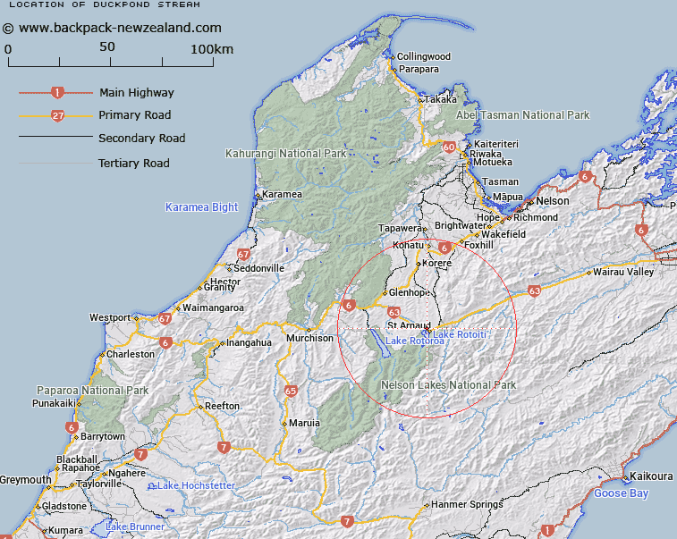
Map showing location of Duckpond Stream


LINZ description: Right bank tributary of Buller River rising in the hills 1.5km North of Saint Arnaud township, flowing westward, and joining Buller River 1.25km downstream from the Lake Rotoiti outlet. Block XIII Motupiko Survey District.
Latitude: -41.792537
Longitude: 172.830776
Northing: 5373243.9
Easting: 1585939.8
Land District: Nelson
Feat Type: Stream


Scroll down to see a more detailed road map and below that a topographical map showing the location of Duckpond Stream. The road map has been supplied by openstreetmap and the topographical map of Duckpond Stream has been supplied by Land Information New Zealand (LINZ).

Yes you can use the top static map for you school/university project or personal website with a link back. Contact me for any commercial use.

Duckpond Stream Map New Zealand


New Zealand places in our database
[ A ] [ B ] [ C ] [ D ] [ E ] [ F ] [ G ] [ H ] [ I ] [ J ] [ K ] [ L ] [ M ] [ N ] [ O ] [ P ] [ Q ] [ R ] [ S ] [ T ] [ U ] [ V ] [ W ] [ X ] [ Y ] [ Z ]


Closest 20 Streams to Duckpond Stream

Duckpond Stream ( 0km )   Black Valley Stream ( 2.76km )   Tongue Spur Stream ( 3.48km )   Borlase Stream ( 4km )   Robert Stream ( 4.11km )   St Arnaud Stream ( 4.37km )   Speargrass Creek ( 4.62km )   Te Horowai / Speargrass Creek ( 4.62km )   Teetotal Creek ( 4.7km )   Roundell Creek ( 5.2km )   Whisky Creek ( 5.72km )   Seventeen Creek ( 6.09km )   Pakihi Creek ( 6.43km )   Deception Creek ( 7.55km )   Prospector Creek ( 7.6km )   No Catchem Stream ( 8.08km )   Chinaman Stream ( 8.22km )   5 Mile Creek ( 8.23km )   Merry Stream ( 8.67km )   Chandler Stream ( 8.75km )   Rough Creek ( 8.96km )   Diggers Creek ( 8.98km )   Maggie Creek ( 9.01km )   Coldwater Stream ( 9.28km )   Skeat Creek ( 9.32km )   Homestead Creek ( 9.49km )   Snows Stream ( 10.36km )   Woolshed Stream ( 10.48km )   Clearwater Stream ( 10.52km )   Two Mile Creek ( 10.62km )   Rocky Creek ( 10.75km )   Maud Creek ( 10.94km )   Bull Paddock Stream ( 11.25km )   Hodgson Stream ( 11.45km )   Shift Creek ( 11.48km )   Ngaro Stream ( 11.48km )   Sandfly Stream ( 11.96km )   Tier Stream ( 12.48km )   Swampy Creek ( 12.61km )   Six Mile Creek ( 12.68km )