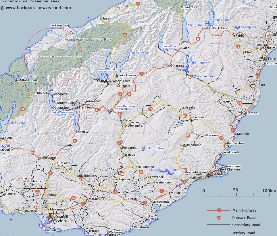
Map showing location of Toreador Peak


LINZ description: At the head of the Limbo Glacier
Latitude: -44.361714
Longitude: 168.410817
Northing: 5077700
Easting: 1234300
Land District: Otago
Feat Type: Hill


Scroll down to see a more detailed road map and below that a topographical map showing the location of Toreador Peak. The road map has been supplied by openstreetmap and the topographical map of Toreador Peak has been supplied by Land Information New Zealand (LINZ).

Yes you can use the top static map for you school/university project or personal website with a link back. Contact me for any commercial use.

Toreador Peak Map New Zealand


New Zealand places in our database
[ A ] [ B ] [ C ] [ D ] [ E ] [ F ] [ G ] [ H ] [ I ] [ J ] [ K ] [ L ] [ M ] [ N ] [ O ] [ P ] [ Q ] [ R ] [ S ] [ T ] [ U ] [ V ] [ W ] [ X ] [ Y ] [ Z ]


Closest 20 Hills to Toreador Peak

Typhoon Peak ( 0.63km )   Tempest Peak ( 0.92km )   Matador ( 1.21km )   Holloway Peak ( 1.5km )   Mount Temple ( 1.85km )   Picador ( 2.3km )   Retreat Peaks ( 2.31km )   Trinity ( 2.61km )   Farrell Peak ( 3.4km )   Redoubt Peaks ( 4.68km )   Gyrae ( 4.83km )   Remote Peaks ( 5.5km )   Darkness Peak ( 6km )   Camp Oven Dome ( 6.13km )   Futurity Rock ( 6.47km )   Pyramid ( 6.51km )   Five Fingers ( 6.6km )   Red Mountain ( 6.93km )   Pic d'argent ( 6.93km )   Little Ark ( 7.03km )   Gable Peak ( 7.12km )   Elespie ( 7.27km )   Ark ( 7.49km )   Buttress ( 7.52km )   The Tower ( 7.91km )   Alfred Peak ( 8.16km )   Cilicia Peak ( 8.53km )   Mount Caria ( 9.1km )   Passchendaele Peak ( 9.1km )   Little Red Hill ( 9.5km )   Beacon ( 9.94km )   Battlement Peak ( 10.16km )   Daedelus ( 10.18km )   Allison Mountain ( 10.28km )   Destiny Peak ( 10.53km )   Blockade Peak ( 10.93km )   Annetta Mountain ( 11.06km )   Climax Peak ( 11.15km )   Joe Peak ( 11.26km )   McClimont Peak ( 11.61km )