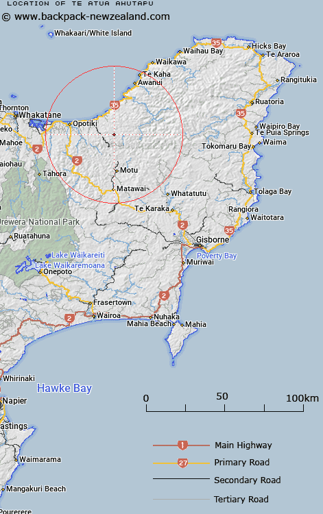
Map showing location of Te Atua Ahutapu


LINZ description: Located east of Waiopu Stream.
Latitude: -38.061838
Longitude: 177.535835
Northing: 5777600
Easting: 1998000
Land District: Gisborne
Feat Type: Trig Station


Scroll down to see a more detailed road map and below that a topographical map showing the location of Te Atua Ahutapu. The road map has been supplied by openstreetmap and the topographical map of Te Atua Ahutapu has been supplied by Land Information New Zealand (LINZ).

Yes you can use the top static map for you school/university project or personal website with a link back. Contact me for any commercial use.

Te Atua Ahutapu Map New Zealand


New Zealand places in our database
[ A ] [ B ] [ C ] [ D ] [ E ] [ F ] [ G ] [ H ] [ I ] [ J ] [ K ] [ L ] [ M ] [ N ] [ O ] [ P ] [ Q ] [ R ] [ S ] [ T ] [ U ] [ V ] [ W ] [ X ] [ Y ] [ Z ]


Closest 20 Trig Stations to Te Atua Ahutapu

Te Atua Ahutapu ( 0km )   Te Atuahautapu ( 0km )   Te Pakora ( 2.91km )   Te Pakera ( 2.91km )   Ngawhenga ( 7.83km )   Ngawehenga ( 7.83km )   Tarakeha ( 13.52km )   Tarakeho ( 13.52km )   Hamutinui ( 14.08km )   Hamutuni ( 14.08km )   Ratahi ( 17.11km )   Ratatahi ( 17.11km )   Puhikereru ( 17.76km )   Pukekeruru ( 17.76km )   Motuhora ( 24.08km )   Moutohora ( 24.08km )   Pukekiore ( 26.83km )   Maungawhiorangi ( 28.51km )   Maungahunia ( 28.74km )   Maungahaumi ( 28.74km )   Mangahaumia ( 28.74km )   Te Iwi Roa ( 30.49km )   Te Iwiroa ( 30.49km )   Tawhitiapaka ( 30.92km )   Tawhiti ( 30.92km )   Pataua ( 34.56km )   Patawa ( 34.56km )   Miringahei ( 38.32km )   Meringahei ( 38.32km )   Tutamoi ( 42.36km )   Tutamoe ( 42.36km )   Ngapukeriki ( 53.17km )   Ngapuketurua ( 53.17km )   Taumatamiere ( 58.95km )   Taumatamiri ( 58.95km )   Tapapanui ( 61.15km )   Pokiameha ( 61.64km )   Tokiameha ( 61.64km )   Paripoupou ( 66.36km )   Parepoupou ( 66.36km )