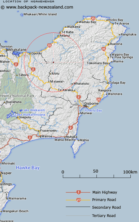
Map showing location of Ngawehenga


LINZ description: Located on the east of Takaputahi river, halfway between Takaputahi and Toatoa.
Latitude: -38.115415
Longitude: 177.593869
Northing: 5771400
Easting: 2002800
Land District: Gisborne
Feat Type: Trig Station


Scroll down to see a more detailed road map and below that a topographical map showing the location of Ngawehenga. The road map has been supplied by openstreetmap and the topographical map of Ngawehenga has been supplied by Land Information New Zealand (LINZ).

Yes you can use the top static map for you school/university project or personal website with a link back. Contact me for any commercial use.

Ngawehenga Map New Zealand


New Zealand places in our database
[ A ] [ B ] [ C ] [ D ] [ E ] [ F ] [ G ] [ H ] [ I ] [ J ] [ K ] [ L ] [ M ] [ N ] [ O ] [ P ] [ Q ] [ R ] [ S ] [ T ] [ U ] [ V ] [ W ] [ X ] [ Y ] [ Z ]


Closest 20 Trig Stations to Ngawehenga

Hamutinui ( 6.52km )   Hamutuni ( 6.52km )   Te Atua Ahutapu ( 7.83km )   Te Atuahautapu ( 7.83km )   Te Pakora ( 8.66km )   Te Pakera ( 8.66km )   Ratahi ( 15.42km )   Ratatahi ( 15.42km )   Puhikereru ( 18.06km )   Pukekeruru ( 18.06km )   Pukekiore ( 19.37km )   Motuhora ( 20.12km )   Moutohora ( 20.12km )   Tarakeha ( 21.35km )   Tarakeho ( 21.35km )   Mangahaumia ( 21.41km )   Maungahaumi ( 21.41km )   Maungahunia ( 21.41km )   Te Iwiroa ( 22.72km )   Te Iwi Roa ( 22.72km )   Tawhiti ( 23.51km )   Tawhitiapaka ( 23.51km )   Maungawhiorangi ( 31.37km )   Miringahei ( 33.3km )   Meringahei ( 33.3km )   Tutamoe ( 35.25km )   Tutamoi ( 35.25km )   Pataua ( 40.54km )   Patawa ( 40.54km )   Ngapukeriki ( 51.16km )   Ngapuketurua ( 51.16km )   Tapapanui ( 53.4km )   Tokiameha ( 57.88km )   Pokiameha ( 57.88km )   Paripoupou ( 59.57km )   Parepoupou ( 59.57km )   Kohirikiriki ( 62.47km )   Koherekireki ( 62.47km )   Taumatamiere ( 63.11km )   Taumatamiri ( 63.11km )