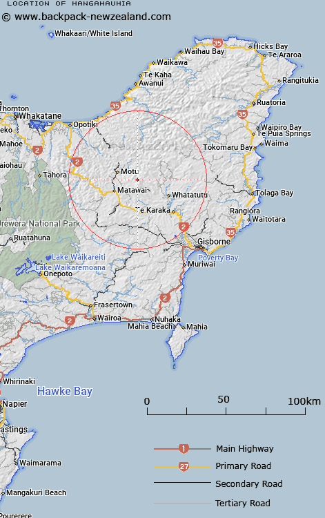
Map showing location of Mangahaumia


LINZ description: Trig Station on Maungahaumi (hill) on a height of 1213m.
Latitude: -38.29997
Longitude: 177.663791
Northing: 5750600
Easting: 2007900
Land District: Gisborne
Feat Type: Trig Station


Scroll down to see a more detailed road map and below that a topographical map showing the location of Mangahaumia. The road map has been supplied by openstreetmap and the topographical map of Mangahaumia has been supplied by Land Information New Zealand (LINZ).

Yes you can use the top static map for you school/university project or personal website with a link back. Contact me for any commercial use.

Mangahaumia Map New Zealand


New Zealand places in our database
[ A ] [ B ] [ C ] [ D ] [ E ] [ F ] [ G ] [ H ] [ I ] [ J ] [ K ] [ L ] [ M ] [ N ] [ O ] [ P ] [ Q ] [ R ] [ S ] [ T ] [ U ] [ V ] [ W ] [ X ] [ Y ] [ Z ]


Closest 20 Trig Stations to Mangahaumia

Te Iwiroa ( 12.18km )   Te Iwi Roa ( 12.18km )   Hamutinui ( 14.89km )   Hamutuni ( 14.89km )   Pukekiore ( 15.68km )   Motuhora ( 15.92km )   Moutohora ( 15.92km )   Tawhitiapaka ( 17.51km )   Tawhiti ( 17.51km )   Ngawehenga ( 21.41km )   Ngawhenga ( 21.41km )   Tutamoi ( 27.48km )   Tutamoe ( 27.48km )   Te Pakera ( 28.33km )   Te Pakora ( 28.33km )   Te Atua Ahutapu ( 28.74km )   Te Atuahautapu ( 28.74km )   Ratahi ( 31.31km )   Ratatahi ( 31.31km )   Tapapanui ( 33.23km )   Pukekeruru ( 35.6km )   Puhikereru ( 35.6km )   Meringahei ( 36.01km )   Miringahei ( 36.01km )   Maungawhiorangi ( 39.28km )   Tarakeha ( 41.69km )   Tarakeho ( 41.69km )   Ngapukeriki ( 42.82km )   Ngapuketurua ( 42.82km )   Kohirikiriki ( 43.54km )   Koherekireki ( 43.54km )   Te Aitangaamahaki ( 49.59km )   Te Itanga Mahaki ( 49.59km )   Paripoupou ( 50.68km )   Parepoupou ( 50.68km )   Patawa ( 54.43km )   Pataua ( 54.43km )   Rerepi ( 55.25km )   Rarepe ( 55.25km )   Whakapunake ( 56.68km )