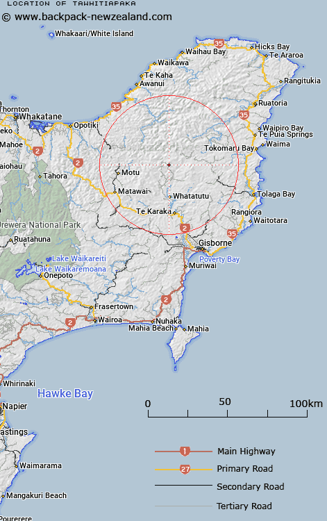
Map showing location of Tawhitiapaka


LINZ description: In Mangatu Forest.
Latitude: -38.213912
Longitude: 177.831772
Northing: 5759400
Easting: 2023100
Land District: Gisborne
Feat Type: Trig Station


Scroll down to see a more detailed road map and below that a topographical map showing the location of Tawhitiapaka. The road map has been supplied by openstreetmap and the topographical map of Tawhitiapaka has been supplied by Land Information New Zealand (LINZ).

Yes you can use the top static map for you school/university project or personal website with a link back. Contact me for any commercial use.

Tawhitiapaka Map New Zealand


New Zealand places in our database
[ A ] [ B ] [ C ] [ D ] [ E ] [ F ] [ G ] [ H ] [ I ] [ J ] [ K ] [ L ] [ M ] [ N ] [ O ] [ P ] [ Q ] [ R ] [ S ] [ T ] [ U ] [ V ] [ W ] [ X ] [ Y ] [ Z ]


Closest 20 Trig Stations to Tawhitiapaka

Pukekiore ( 4.14km )   Te Iwiroa ( 5.58km )   Te Iwi Roa ( 5.58km )   Tutamoe ( 12.08km )   Tutamoi ( 12.08km )   Maungahunia ( 17.51km )   Mangahaumia ( 17.51km )   Maungahaumi ( 17.51km )   Meringahei ( 18.85km )   Miringahei ( 18.85km )   Hamutinui ( 19.38km )   Hamutuni ( 19.38km )   Ratahi ( 23.25km )   Ratatahi ( 23.25km )   Ngawhenga ( 23.51km )   Ngawehenga ( 23.51km )   Puhikereru ( 27.85km )   Pukekeruru ( 27.85km )   Te Atuahautapu ( 30.92km )   Te Atua Ahutapu ( 30.92km )   Motuhora ( 31.09km )   Moutohora ( 31.09km )   Te Pakora ( 32.16km )   Te Pakera ( 32.16km )   Tapapanui ( 35.16km )   Parepoupou ( 36.66km )   Paripoupou ( 36.66km )   Tokiameha ( 43.72km )   Pokiameha ( 43.72km )   Tarakeha ( 44.18km )   Tarakeho ( 44.18km )   Maungawhiorangi ( 51.61km )   Otiki ( 57.8km )   Kohirikiriki ( 58.11km )   Koherekireki ( 58.11km )   Ngapuketurua ( 60.25km )   Ngapukeriki ( 60.25km )   Rarepe ( 62.46km )   Rerepi ( 62.46km )   Pataua ( 63.56km )