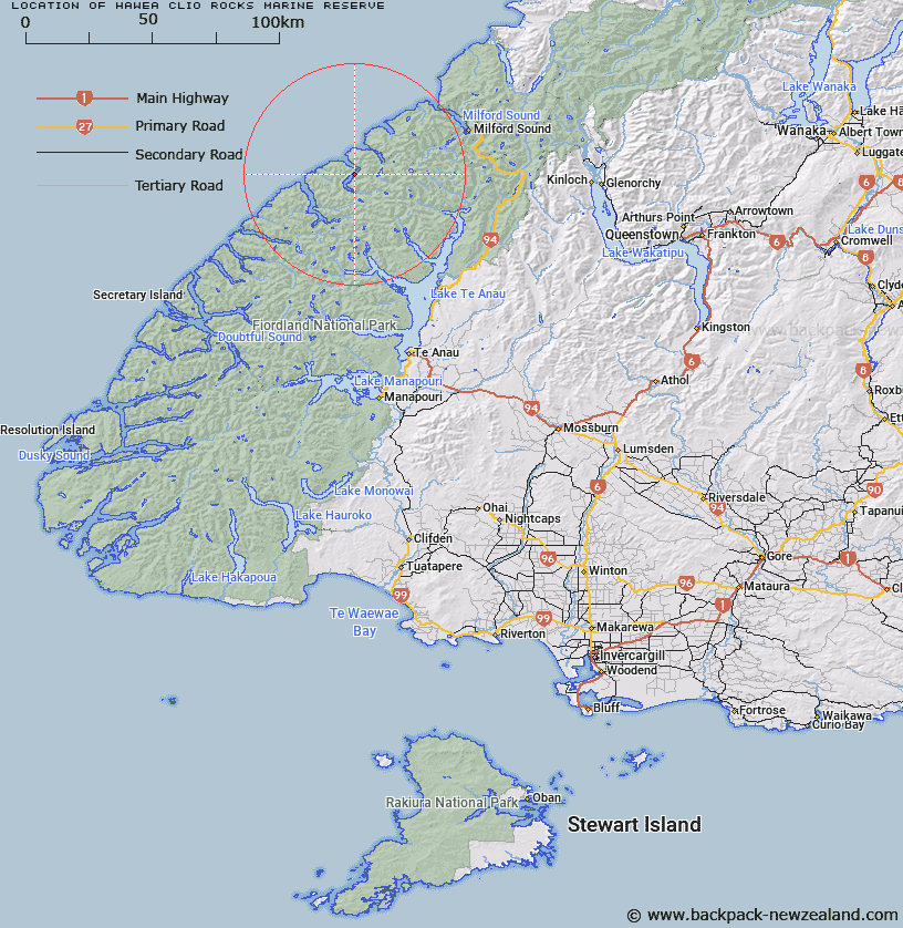
Map showing location of Hawea (Clio Rocks) Marine Reserve


LINZ description: S.35 NZGB Act 2008 validation
Latitude: -44.817811
Longitude: 167.52732
Northing: 5022700
Easting: 1167300
Land District: Southland
Feat Type: Marine Reserve


Scroll down to see a more detailed road map and below that a topographical map showing the location of Hawea (Clio Rocks) Marine Reserve. The road map has been supplied by openstreetmap and the topographical map of Hawea (Clio Rocks) Marine Reserve has been supplied by Land Information New Zealand (LINZ).

Yes you can use the top static map for you school/university project or personal website with a link back. Contact me for any commercial use.

Hawea (Clio Rocks) Marine Reserve Map New Zealand


New Zealand places in our database
[ A ] [ B ] [ C ] [ D ] [ E ] [ F ] [ G ] [ H ] [ I ] [ J ] [ K ] [ L ] [ M ] [ N ] [ O ] [ P ] [ Q ] [ R ] [ S ] [ T ] [ U ] [ V ] [ W ] [ X ] [ Y ] [ Z ]


Closest 20 Marine Reserves to Hawea (Clio Rocks) Marine Reserve

Te Hapua (Sutherland Sound) Marine Reserve ( 9.45km )   Piopiotahi (Milford Sound) Marine Reserve ( 35.49km )   Kahukura (Gold Arm) Marine Reserve ( 45.83km )   Kutu Parera (Gaer Arm) Marine Reserve ( 61.33km )   Te Awaatu Channel (The Gut) Marine Reserve ( 69.99km )   Taipari Roa (Elizabeth Island) Marine Reserve ( 74.93km )   Hautai Marine Reserve ( 81.35km )   Moana Uta (West Jacket Arm) Marine Reserve ( 106.62km )   Taumoana (Five Finger Peninsula) Marine Reserve ( 124.68km )   Te Tapuwae o Hua (Long Sound) Marine Reserve ( 143.55km )   Tauparik?k? Marine Reserve ( 174.67km )   Ulva Island - Te Wharawhara Marine Reserve ( 240.32km )   Waiau Glacier Coast Marine Reserve ( 267.48km )   Punakaiki Marine Reserve ( 426.82km )   Akaroa Marine Reserve ( 444.46km )   Pohatu Marine Reserve ( 449.11km )   Hikurangi Marine Reserve ( 550.68km )   Kahurangi Marine Reserve ( 564.35km )   Westhaven (Te Tai Tapu) Marine Reserve ( 620.53km )   Horoirangi Marine Reserve ( 625.44km )   Tonga Island Marine Reserve ( 628.9km )   Long Island - Kokomohua Marine Reserve ( 686.75km )   Taputeranga Marine Reserve ( 702.35km )   Kapiti Marine Reserve ( 748.05km )   Tapuae Marine Reserve ( 832.29km )   Parininihi Marine Reserve ( 879.02km )   Te Angiangi Marine Reserve ( 922.56km )   Motu Manawa-Pollen Island Marine Reserve ( 1068.64km )   Long Bay-Okura Marine Reserve ( 1090.08km )   Te Matuku Marine Reserve ( 1094.48km )   Tuhua (Mayor Island) Marine Reserve ( 1113.34km )   Te Tapuwae o Rongokako Marine Reserve ( 1123.07km )   T?wharanui Marine Reserve ( 1123.93km )   Whanganui A Hei (Cathedral Cove) Marine Reserve ( 1127.71km )   Cape Rodney-Okakari Point Marine Reserve ( 1130.98km )   Te Paepae o Aotea (Volkner Rocks) Marine Reserve ( 1144.42km )   Whangarei Harbour Marine Reserve ( 1161.34km )   Poor Knights Islands Marine Reserve ( 1202.89km )