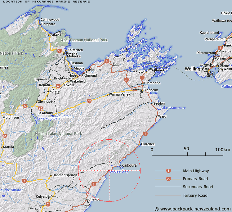
Map showing location of Hikurangi Marine Reserve


LINZ description: Encompasses the undersea feature name Kaikōura Canyon which is the terminus of the south-western end of Hikurangi Trough.
Latitude: -42.4655
Longitude: 173.552361
Northing: 5298390
Easting: 1645410.4
Land District: Marlborough
Feat Type: Marine Reserve


Scroll down to see a more detailed road map and below that a topographical map showing the location of Hikurangi Marine Reserve. The road map has been supplied by openstreetmap and the topographical map of Hikurangi Marine Reserve has been supplied by Land Information New Zealand (LINZ).

Yes you can use the top static map for you school/university project or personal website with a link back. Contact me for any commercial use.

Hikurangi Marine Reserve Map New Zealand


New Zealand places in our database
[ A ] [ B ] [ C ] [ D ] [ E ] [ F ] [ G ] [ H ] [ I ] [ J ] [ K ] [ L ] [ M ] [ N ] [ O ] [ P ] [ Q ] [ R ] [ S ] [ T ] [ U ] [ V ] [ W ] [ X ] [ Y ] [ Z ]


Closest 20 Marine Reserves to Hikurangi Marine Reserve

Horoirangi Marine Reserve ( 145.58km )   Taputeranga Marine Reserve ( 159.15km )   Long Island - Kokomohua Marine Reserve ( 162.15km )   Pohatu Marine Reserve ( 162.8km )   Akaroa Marine Reserve ( 164.51km )   Tonga Island Marine Reserve ( 180.69km )   Punakaiki Marine Reserve ( 188.71km )   Kahurangi Marine Reserve ( 205.27km )   Kapiti Marine Reserve ( 213.29km )   Westhaven (Te Tai Tapu) Marine Reserve ( 222.35km )   Waiau Glacier Coast Marine Reserve ( 297.02km )   Te Angiangi Marine Reserve ( 376.35km )   Tapuae Marine Reserve ( 378.9km )   Tauparik?k? Marine Reserve ( 385.39km )   Parininihi Marine Reserve ( 408.76km )   Hautai Marine Reserve ( 480.47km )   Piopiotahi (Milford Sound) Marine Reserve ( 515.66km )   Te Hapua (Sutherland Sound) Marine Reserve ( 541.6km )   Hawea (Clio Rocks) Marine Reserve ( 550.68km )   Te Tapuwae o Rongokako Marine Reserve ( 582.73km )   Kahukura (Gold Arm) Marine Reserve ( 593.2km )   Kutu Parera (Gaer Arm) Marine Reserve ( 601.34km )   Taipari Roa (Elizabeth Island) Marine Reserve ( 610.76km )   Te Awaatu Channel (The Gut) Marine Reserve ( 615.48km )   Tuhua (Mayor Island) Marine Reserve ( 623.04km )   Motu Manawa-Pollen Island Marine Reserve ( 630.42km )   Te Paepae o Aotea (Volkner Rocks) Marine Reserve ( 632.98km )   Te Matuku Marine Reserve ( 641.75km )   Moana Uta (West Jacket Arm) Marine Reserve ( 642.17km )   Long Bay-Okura Marine Reserve ( 652.34km )   Whanganui A Hei (Cathedral Cove) Marine Reserve ( 656.4km )   Ulva Island - Te Wharawhara Marine Reserve ( 657.48km )   Taumoana (Five Finger Peninsula) Marine Reserve ( 665.14km )   Te Tapuwae o Hua (Long Sound) Marine Reserve ( 666.18km )   T?wharanui Marine Reserve ( 687.63km )   Cape Rodney-Okakari Point Marine Reserve ( 697.66km )   Whangarei Harbour Marine Reserve ( 748.45km )   Poor Knights Islands Marine Reserve ( 781.83km )