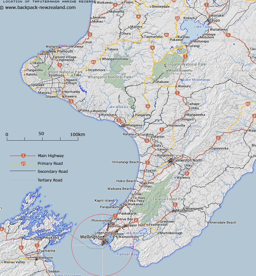
Map showing location of Taputeranga Marine Reserve


LINZ description: This reserve spans the coast along some of Wellington’s southern suburbs, and is easy to reach by city bus. No two days are the same at Taputeranga - the weather is changeable and the water churns through Cook Strait, creating a moody and complex undersea environment. It lies at the meeting place of two oceanic currents and is home to a richly varied mixture of animals and plants. It is particularly popular with crabs, lobsters, starfish and octopus. Kelp plants up to 20 m tall grow in sheltered places. Sinclair Head and Red Rocks Scientific Reserves can be found 1 km west of Taputeranga. Sinclair Head/Te Rimurapa is a winter haul-out for the New Zealand fur seal. Taputeranga Marine Reserve is located on the Wellington south coast, approximately 6 km from the city centre.
Latitude: -41.356389
Longitude: 174.768056
Northing: 5420171.2
Easting: 1747895.4
Land District: Wellington
Feat Type: Marine Reserve


Scroll down to see a more detailed road map and below that a topographical map showing the location of Taputeranga Marine Reserve. The road map has been supplied by openstreetmap and the topographical map of Taputeranga Marine Reserve has been supplied by Land Information New Zealand (LINZ).

Yes you can use the top static map for you school/university project or personal website with a link back. Contact me for any commercial use.

Taputeranga Marine Reserve Map New Zealand


New Zealand places in our database
[ A ] [ B ] [ C ] [ D ] [ E ] [ F ] [ G ] [ H ] [ I ] [ J ] [ K ] [ L ] [ M ] [ N ] [ O ] [ P ] [ Q ] [ R ] [ S ] [ T ] [ U ] [ V ] [ W ] [ X ] [ Y ] [ Z ]


Closest 20 Marine Reserves to Taputeranga Marine Reserve

Long Island - Kokomohua Marine Reserve ( 48.38km )   Kapiti Marine Reserve ( 57.65km )   Horoirangi Marine Reserve ( 118.26km )   Tonga Island Marine Reserve ( 151.69km )   Hikurangi Marine Reserve ( 159.15km )   Westhaven (Te Tai Tapu) Marine Reserve ( 204.85km )   Te Angiangi Marine Reserve ( 220.23km )   Kahurangi Marine Reserve ( 229.26km )   Tapuae Marine Reserve ( 262.2km )   Parininihi Marine Reserve ( 278.02km )   Punakaiki Marine Reserve ( 299.98km )   Pohatu Marine Reserve ( 314.65km )   Akaroa Marine Reserve ( 317.21km )   Te Tapuwae o Rongokako Marine Reserve ( 424.25km )   Waiau Glacier Coast Marine Reserve ( 440.1km )   Tuhua (Mayor Island) Marine Reserve ( 473.09km )   Te Paepae o Aotea (Volkner Rocks) Marine Reserve ( 476.81km )   Motu Manawa-Pollen Island Marine Reserve ( 499.83km )   Te Matuku Marine Reserve ( 504.92km )   Whanganui A Hei (Cathedral Cove) Marine Reserve ( 512.19km )   Long Bay-Okura Marine Reserve ( 520.95km )   Tauparik?k? Marine Reserve ( 532.1km )   T?wharanui Marine Reserve ( 555.36km )   Cape Rodney-Okakari Point Marine Reserve ( 566.14km )   Whangarei Harbour Marine Reserve ( 622.63km )   Hautai Marine Reserve ( 628.7km )   Poor Knights Islands Marine Reserve ( 651.86km )   Piopiotahi (Milford Sound) Marine Reserve ( 666.98km )   Te Hapua (Sutherland Sound) Marine Reserve ( 693.09km )   Hawea (Clio Rocks) Marine Reserve ( 702.35km )   Kahukura (Gold Arm) Marine Reserve ( 745.99km )   Kutu Parera (Gaer Arm) Marine Reserve ( 755.26km )   Taipari Roa (Elizabeth Island) Marine Reserve ( 765.27km )   Te Awaatu Channel (The Gut) Marine Reserve ( 768.83km )   Moana Uta (West Jacket Arm) Marine Reserve ( 797.13km )   Ulva Island - Te Wharawhara Marine Reserve ( 816.62km )   Taumoana (Five Finger Peninsula) Marine Reserve ( 819.72km )   Te Tapuwae o Hua (Long Sound) Marine Reserve ( 822.56km )