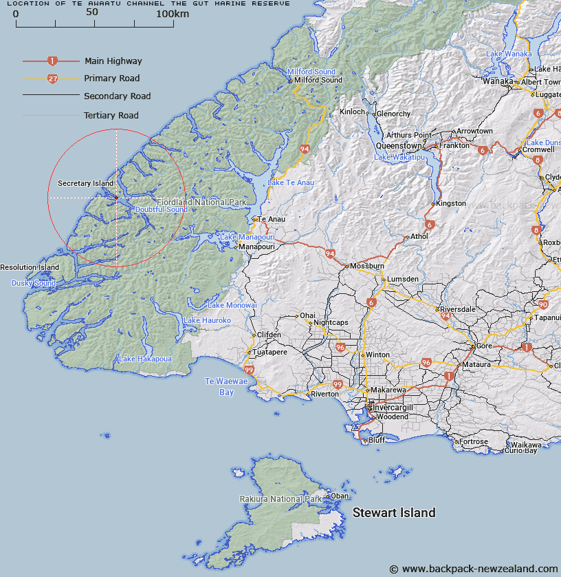
Map showing location of Te Awaatu Channel (The Gut) Marine Reserve


LINZ description: At 93 hectares, this is the smallest marine reserve in Fiordland. It is sandwiched between Bauza and Secretary Islands and has a high tidal flow. The reserve is much shallower than the surrounding deep-water basin habitats, which are the deepest in Fiordland, reaching depths of about 420 metres. There are significant rock wall and deep reef habitats, and the reserve is known for its sea pens and other suspension feeders, including the red and black corals, zooanthids and lampshells. Monitoring has shown more and larger rock lobsters exist in the reserve than outside it.
Latitude: -45.296944
Longitude: 166.949444
Northing: 4966225.1
Easting: 1125602.5
Land District: Southland
Feat Type: Marine Reserve


Scroll down to see a more detailed road map and below that a topographical map showing the location of Te Awaatu Channel (The Gut) Marine Reserve. The road map has been supplied by openstreetmap and the topographical map of Te Awaatu Channel (The Gut) Marine Reserve has been supplied by Land Information New Zealand (LINZ).

Yes you can use the top static map for you school/university project or personal website with a link back. Contact me for any commercial use.

Te Awaatu Channel (The Gut) Marine Reserve Map New Zealand


New Zealand places in our database
[ A ] [ B ] [ C ] [ D ] [ E ] [ F ] [ G ] [ H ] [ I ] [ J ] [ K ] [ L ] [ M ] [ N ] [ O ] [ P ] [ Q ] [ R ] [ S ] [ T ] [ U ] [ V ] [ W ] [ X ] [ Y ] [ Z ]


Closest 20 Marine Reserves to Te Awaatu Channel (The Gut) Marine Reserve

Kutu Parera (Gaer Arm) Marine Reserve ( 16.71km )   Taipari Roa (Elizabeth Island) Marine Reserve ( 20.05km )   Kahukura (Gold Arm) Marine Reserve ( 24.18km )   Moana Uta (West Jacket Arm) Marine Reserve ( 39.65km )   Taumoana (Five Finger Peninsula) Marine Reserve ( 54.81km )   Hawea (Clio Rocks) Marine Reserve ( 69.99km )   Te Hapua (Sutherland Sound) Marine Reserve ( 79.36km )   Te Tapuwae o Hua (Long Sound) Marine Reserve ( 79.38km )   Piopiotahi (Milford Sound) Marine Reserve ( 104.73km )   Hautai Marine Reserve ( 151.22km )   Ulva Island - Te Wharawhara Marine Reserve ( 203.46km )   Tauparik?k? Marine Reserve ( 244.19km )   Waiau Glacier Coast Marine Reserve ( 336.6km )   Punakaiki Marine Reserve ( 496.41km )   Akaroa Marine Reserve ( 501.38km )   Pohatu Marine Reserve ( 505.93km )   Hikurangi Marine Reserve ( 615.48km )   Kahurangi Marine Reserve ( 634.29km )   Westhaven (Te Tai Tapu) Marine Reserve ( 690.45km )   Horoirangi Marine Reserve ( 694.21km )   Tonga Island Marine Reserve ( 698.34km )   Long Island - Kokomohua Marine Reserve ( 754.49km )   Taputeranga Marine Reserve ( 768.83km )   Kapiti Marine Reserve ( 815.46km )   Tapuae Marine Reserve ( 902.25km )   Parininihi Marine Reserve ( 948.9km )   Te Angiangi Marine Reserve ( 989.04km )   Motu Manawa-Pollen Island Marine Reserve ( 1138.5km )   Long Bay-Okura Marine Reserve ( 1159.92km )   Te Matuku Marine Reserve ( 1164.43km )   Tuhua (Mayor Island) Marine Reserve ( 1183.18km )   Te Tapuwae o Rongokako Marine Reserve ( 1190.64km )   T?wharanui Marine Reserve ( 1193.73km )   Whanganui A Hei (Cathedral Cove) Marine Reserve ( 1197.69km )   Cape Rodney-Okakari Point Marine Reserve ( 1200.73km )   Te Paepae o Aotea (Volkner Rocks) Marine Reserve ( 1213.83km )   Whangarei Harbour Marine Reserve ( 1230.69km )   Poor Knights Islands Marine Reserve ( 1272.35km )