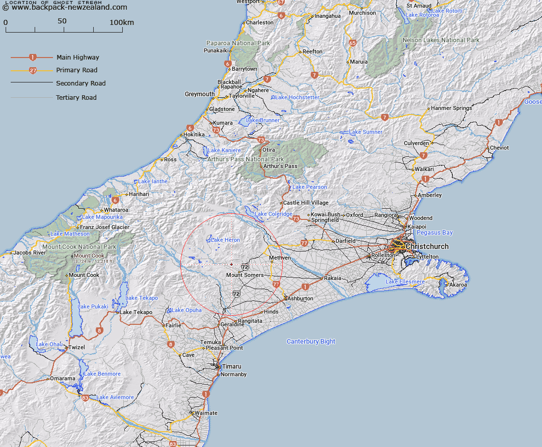
Map showing location of Ghost Stream


LINZ description: Right bank tributary of Stony Creek rising 2.5km North-west of Mount Somers [Trig. KK (Geodetic Code 1117)], flowing southward and joining Stony Creek 1.6km North-west of Mount Somers Homestead. Block VI, Alford Survey District.
Latitude: -43.654451
Longitude: 171.343454
Northing: 5165172.1
Easting: 1466418.6
Land District: Canterbury
Feat Type: Stream


Scroll down to see a more detailed road map and below that a topographical map showing the location of Ghost Stream. The road map has been supplied by openstreetmap and the topographical map of Ghost Stream has been supplied by Land Information New Zealand (LINZ).

Yes you can use the top static map for you school/university project or personal website with a link back. Contact me for any commercial use.

Ghost Stream Map New Zealand


New Zealand places in our database
[ A ] [ B ] [ C ] [ D ] [ E ] [ F ] [ G ] [ H ] [ I ] [ J ] [ K ] [ L ] [ M ] [ N ] [ O ] [ P ] [ Q ] [ R ] [ S ] [ T ] [ U ] [ V ] [ W ] [ X ] [ Y ] [ Z ]


Closest 20 Streams to Ghost Stream

Stony Creek ( 1.4km )   Chapmans Creek ( 2.5km )   Woolshed Creek ( 3.09km )   Caves Stream ( 4.25km )   Stevenson Stream ( 4.25km )   Tinstone Creek ( 4.75km )   Reid Stream ( 4.86km )   Blondin Stream ( 5.53km )   Hinds River North Branch ( 6.22km )   Bowyers Stream ( 6.32km )   Stour River ( 6.45km )   Morgan Stream ( 6.48km )   Furze Stream ( 6.64km )   Buccleugh Stream ( 6.7km )   Flynn Stream ( 7.23km )   Buccleuch Stream ( 7.39km )   Weta Stream ( 7.61km )   Pony Stream ( 7.62km )   South Branch Ashburton River ( 7.65km )   South Branch Ashburton River/Hakatere ( 7.65km )   The Mill Creek ( 8.09km )   Gawler Stream ( 8.32km )   Limestone Creek ( 8.48km )   Blue Duck Stream ( 8.76km )   Staveley Stream ( 8.77km )   Picnic Creek ( 9.1km )   Little Hinds Stream ( 9.41km )   Orr Stream ( 9.63km )   Diggers Creek ( 10.27km )   Hutt Creek ( 10.36km )   Sandrey Stream ( 10.93km )   Saddle Creek ( 11.05km )   Markhams Stream ( 11.11km )   Waterfall Stream ( 11.19km )   Chaffey Stream ( 11.45km )   Hinds River South Branch ( 11.52km )   Broadleaf Stream ( 11.73km )   Stour River East Branch ( 11.78km )   Rangitata Diversion Race ( 11.95km )   Isaac Stream ( 12km )