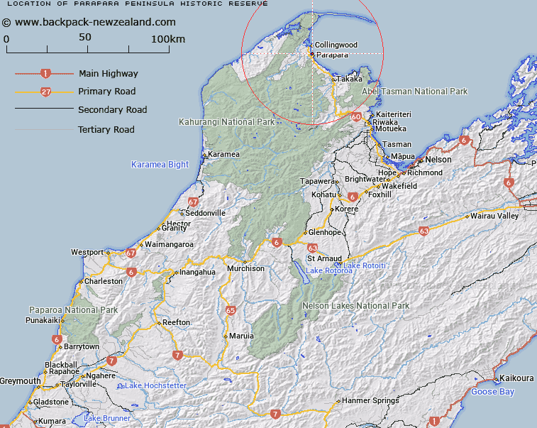
Map showing location of Parapara Peninsula Historic Reserve


LINZ description: As shown in the NgÄti Tama ki Te Tau Ihu Deed of Settlement Plan OTS-202-93. Described as 11.2570 hectares, more or less, being Section 1 SO 460738. All transfer 250684.1. NZTopo50-BN24 737925.
Latitude: -40.718056
Longitude: 172.688611
Northing: 5492494.1
Easting: 1573700.4
Land District: Nelson
Feat Type: Historic Reserve


Scroll down to see a more detailed road map and below that a topographical map showing the location of Parapara Peninsula Historic Reserve. The road map has been supplied by openstreetmap and the topographical map of Parapara Peninsula Historic Reserve has been supplied by Land Information New Zealand (LINZ).

Yes you can use the top static map for you school/university project or personal website with a link back. Contact me for any commercial use.

Parapara Peninsula Historic Reserve Map New Zealand


New Zealand places in our database
[ A ] [ B ] [ C ] [ D ] [ E ] [ F ] [ G ] [ H ] [ I ] [ J ] [ K ] [ L ] [ M ] [ N ] [ O ] [ P ] [ Q ] [ R ] [ S ] [ T ] [ U ] [ V ] [ W ] [ X ] [ Y ] [ Z ]


Closest 20 Historic Reserves to Parapara Peninsula Historic Reserve

Albion Square Historic Reserve ( 79.74km )   Belgrove Windmill Historic Reserve ( 84.49km )   Rai Valley Pioneer Cottage ( 94.19km )   Lyell Historic Reserve ( 131.59km )   Six Mile Historic Reserve ( 132.76km )   Denniston Historic Reserve ( 135.67km )   Ship Cove Historic Reserve ( 136.14km )   Horahora-kakahu Historic Reserve ( 139.22km )   Reefton Historic Courthouse Reserve ( 170.05km )   Reefton School Of Mines Historic Reserve ( 170.09km )   Blacks Point Historic Reserve ( 170.8km )   Te Ana o Matuku Historic Reserve ( 182.22km )   Turnbull House Historic Reserve ( 185.98km )   Government Buildings Historic Reserve ( 186.13km )   Tapuinikau Pa Historic Reserve ( 190.32km )   Matiu Historic Reserve ( 192.28km )   St George's Redoubt Historic Reserve ( 203.67km )   Tataraimaka / St George’s Redoubt Historic Reserve ( 203.67km )   Tataraimaka Pa Historic Reserve ( 203.84km )   Tataraimaka Urup? Historic Reserve ( 203.84km )   Nga Niho Pa Historic Reserve ( 206.22km )   ? Tamakura Historic Reserve ( 208.51km )   Te Koru Pa Historic Reserve ( 208.54km )   Hatters Terrace Historic Reserve ( 211.45km )   Omata Stockade Historic Reserve ( 214.5km )   Shield's Flat Stone Walls Historic Reserve ( 214.64km )   Marsland Hill Historic Reserve ( 218.54km )   Moutoa Gardens Historic Reserve ( 218.98km )   Puketarata-Parihamore Historic Reserve ( 219.75km )   Taumata Historic Reserve ( 224.78km )   Sentry Hill Redoubt Historic Reserve ( 226.78km )   Jacks Mill School Kotuku Historic Reserve ( 227.11km )   Pukerangiora Pa Historic Reserve ( 227.69km )   Mahoetahi Historic Reserve ( 228.37km )   Awa te Take Pa Historic Reserve ( 229.28km )   Puketakauere Pa Historic Reserve ( 230.44km )   Seddon House Historic Reserve ( 246.78km )   Weka Pass Historic Reserve ( 251.55km )   Pou Tehia Historic Reserve ( 266.97km )   Mahinapua Creek Rail Bridge Historic Reserve ( 268.67km )