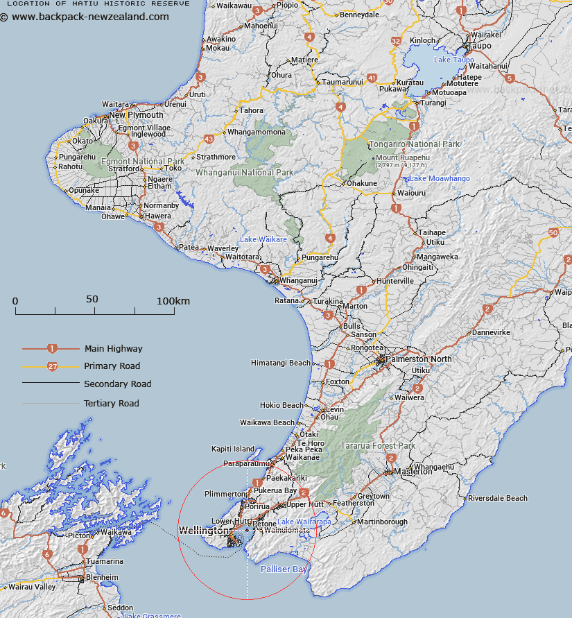
Map showing location of Matiu Historic Reserve


LINZ description: Formerly NZ Gazette 1997 p.3872 Section 62 of the Port Nicholson Block (Taranaki Whānui ki Te Upoko o Te Ika) Claims Settlement Act 2009 refers. NZTopo50-BQ32 GR 562 317
Latitude: -41.257078
Longitude: 174.865379
Northing: 5431026.4
Easting: 1756273.7
Land District: Wellington
Feat Type: Historic Reserve


Scroll down to see a more detailed road map and below that a topographical map showing the location of Matiu Historic Reserve. The road map has been supplied by openstreetmap and the topographical map of Matiu Historic Reserve has been supplied by Land Information New Zealand (LINZ).

Yes you can use the top static map for you school/university project or personal website with a link back. Contact me for any commercial use.

Matiu Historic Reserve Map New Zealand


New Zealand places in our database
[ A ] [ B ] [ C ] [ D ] [ E ] [ F ] [ G ] [ H ] [ I ] [ J ] [ K ] [ L ] [ M ] [ N ] [ O ] [ P ] [ Q ] [ R ] [ S ] [ T ] [ U ] [ V ] [ W ] [ X ] [ Y ] [ Z ]


Closest 20 Historic Reserves to Matiu Historic Reserve

Government Buildings Historic Reserve ( 7.72km )   Turnbull House Historic Reserve ( 7.83km )   Shield's Flat Stone Walls Historic Reserve ( 54.91km )   Ship Cove Historic Reserve ( 56.14km )   Horahora-kakahu Historic Reserve ( 61.55km )   Rai Valley Pioneer Cottage ( 106.23km )   Albion Square Historic Reserve ( 131.73km )   Moutoa Gardens Historic Reserve ( 148.26km )   Belgrove Windmill Historic Reserve ( 160.52km )   Nga Niho Pa Historic Reserve ( 161.55km )   ? Tamakura Historic Reserve ( 176.8km )   Parapara Peninsula Historic Reserve ( 192.28km )   Tikirere Mill Race Historic Reserve ( 202.42km )   Six Mile Historic Reserve ( 222.08km )   Tapuinikau Pa Historic Reserve ( 239.62km )   Lyell Historic Reserve ( 242.17km )   Te Koru Pa Historic Reserve ( 247.89km )   Pukerangiora Pa Historic Reserve ( 249.05km )   Awa te Take Pa Historic Reserve ( 249.37km )   Tataraimaka / St Georges Redoubt Historic Reserve ( 250.13km )   St George's Redoubt Historic Reserve ( 250.13km )   Tataraimaka Pa Historic Reserve ( 250.25km )   Tataraimaka Urup? Historic Reserve ( 250.25km )   Omata Stockade Historic Reserve ( 251.89km )   Otatara Pa Historic Reserve ( 252.45km )   Taumata Historic Reserve ( 252.66km )   Puketarata-Parihamore Historic Reserve ( 252.81km )   Marsland Hill Historic Reserve ( 252.87km )   Sentry Hill Redoubt Historic Reserve ( 253.14km )   Puketakauere Pa Historic Reserve ( 254.94km )   Mahoetahi Historic Reserve ( 255.17km )   Denniston Historic Reserve ( 261.28km )   Weka Pass Historic Reserve ( 262.34km )   Heipipi Pa Historic Reserve ( 265.81km )   Blacks Point Historic Reserve ( 265.98km )   Reefton School Of Mines Historic Reserve ( 266.6km )   Reefton Historic Courthouse Reserve ( 266.62km )   Pou Tehia Historic Reserve ( 272.33km )   Kawau Pa Historic Reserve ( 277.87km )   Tiwaewae Memorial Reserve Historic Reserve ( 284.86km )