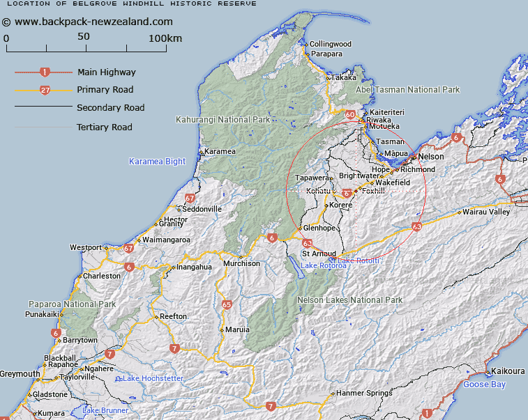
Map showing location of Belgrove Windmill Historic Reserve


LINZ description: Timber/iron railway windmill from 1898. Situated at Highway 6 30km south-west of Nelson.
Latitude: -41.45
Longitude: 172.959444
Northing: 5411285.9
Easting: 1596612.5
Land District: Nelson
Feat Type: Historic Reserve


Scroll down to see a more detailed road map and below that a topographical map showing the location of Belgrove Windmill Historic Reserve. The road map has been supplied by openstreetmap and the topographical map of Belgrove Windmill Historic Reserve has been supplied by Land Information New Zealand (LINZ).

Yes you can use the top static map for you school/university project or personal website with a link back. Contact me for any commercial use.

Belgrove Windmill Historic Reserve Map New Zealand


New Zealand places in our database
[ A ] [ B ] [ C ] [ D ] [ E ] [ F ] [ G ] [ H ] [ I ] [ J ] [ K ] [ L ] [ M ] [ N ] [ O ] [ P ] [ Q ] [ R ] [ S ] [ T ] [ U ] [ V ] [ W ] [ X ] [ Y ] [ Z ]


Closest 20 Historic Reserves to Belgrove Windmill Historic Reserve

Belgrove Windmill Historic Reserve ( 0km )   Albion Square Historic Reserve ( 33.81km )   Rai Valley Pioneer Cottage ( 59.18km )   Six Mile Historic Reserve ( 70.97km )   Parapara Peninsula Historic Reserve ( 84.49km )   Lyell Historic Reserve ( 85.15km )   Horahora-kakahu Historic Reserve ( 98.98km )   Denniston Historic Reserve ( 102.01km )   Ship Cove Historic Reserve ( 113km )   Blacks Point Historic Reserve ( 117km )   Reefton Historic Courthouse Reserve ( 117.06km )   Reefton School Of Mines Historic Reserve ( 117.06km )   Nga Niho Pa Historic Reserve ( 123.1km )   ? Tamakura Historic Reserve ( 124.28km )   Te Ana o Matuku Historic Reserve ( 145.96km )   Turnbull House Historic Reserve ( 152.81km )   Government Buildings Historic Reserve ( 152.94km )   Hatters Terrace Historic Reserve ( 159.72km )   Matiu Historic Reserve ( 160.52km )   Weka Pass Historic Reserve ( 171.57km )   Jacks Mill School Kotuku Historic Reserve ( 173.19km )   Seddon House Historic Reserve ( 196.72km )   Shield's Flat Stone Walls Historic Reserve ( 201.72km )   Mahinapua Creek Rail Bridge Historic Reserve ( 220.94km )   Kapuatohe Historic Reserve ( 224.62km )   Ross Goldsfields Historic Reserve ( 239.28km )   Ross Historic Cemetery Reserve ( 239.57km )   Coronation Hill Historic Reserve ( 241.28km )   Ripapa Island Historic Reserve ( 241.94km )   Cairn Of Peace ( 243.38km )   Moutoa Gardens Historic Reserve ( 244.48km )   Transit Of Venus Historic Reserve ( 246.26km )   Cotons Cob Cottage Historic Reserve ( 246.68km )   Te Puke-ki-wiataha ( 249.94km )   Tapuinikau Pa Historic Reserve ( 255.68km )   Britomart Memorial Historic Reserve ( 263.04km )   Tataraimaka / St George’s Redoubt Historic Reserve ( 269.26km )   St George's Redoubt Historic Reserve ( 269.26km )   Tataraimaka Pa Historic Reserve ( 269.42km )   Tataraimaka Urup? Historic Reserve ( 269.42km )