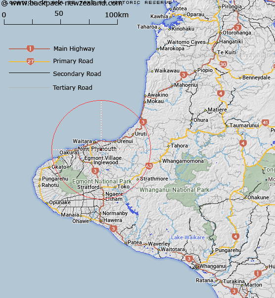
Map showing location of Awa te Take Pa Historic Reserve


LINZ description: Adjacent to Waitara River, approximately 8km south-east of Waitara.
Latitude: -39.058808
Longitude: 174.284283
Northing: 5675912.6
Easting: 1711118.1
Land District: Taranaki
Feat Type: Historic Reserve


Scroll down to see a more detailed road map and below that a topographical map showing the location of Awa te Take Pa Historic Reserve. The road map has been supplied by openstreetmap and the topographical map of Awa te Take Pa Historic Reserve has been supplied by Land Information New Zealand (LINZ).

Yes you can use the top static map for you school/university project or personal website with a link back. Contact me for any commercial use.

Awa te Take Pa Historic Reserve Map New Zealand


New Zealand places in our database
[ A ] [ B ] [ C ] [ D ] [ E ] [ F ] [ G ] [ H ] [ I ] [ J ] [ K ] [ L ] [ M ] [ N ] [ O ] [ P ] [ Q ] [ R ] [ S ] [ T ] [ U ] [ V ] [ W ] [ X ] [ Y ] [ Z ]


Closest 20 Historic Reserves to Awa te Take Pa Historic Reserve

Pukerangiora Pa Historic Reserve ( 1.89km )   Puketakauere Pa Historic Reserve ( 6.65km )   Sentry Hill Redoubt Historic Reserve ( 7.89km )   Mahoetahi Historic Reserve ( 8.86km )   Taumata Historic Reserve ( 9.76km )   Puketarata-Parihamore Historic Reserve ( 16.51km )   Marsland Hill Historic Reserve ( 18.17km )   Omata Stockade Historic Reserve ( 22.47km )   Te Koru Pa Historic Reserve ( 26.59km )   Tataraimaka Pa Historic Reserve ( 35km )   Tataraimaka Urup? Historic Reserve ( 35km )   Tataraimaka / St George’s Redoubt Historic Reserve ( 35.11km )   St George's Redoubt Historic Reserve ( 35.11km )   Pou Tehia Historic Reserve ( 38.11km )   Kawau Pa Historic Reserve ( 42.47km )   Tapuinikau Pa Historic Reserve ( 44.02km )   Puketapu Historic Reserve ( 88.95km )   Moutoa Gardens Historic Reserve ( 117.54km )   Puraho Historic Reserve ( 125.87km )   Kakepuku Mountain Historic Reserve ( 138.44km )   Paterangi Historic Reserve ( 146.19km )   Selwyn Park Historic Reserve ( 147.88km )   Tikirere Mill Race Historic Reserve ( 148.77km )   Opepe Bush Scenic & Historic Reserve ( 170.61km )   Gudex Memorial Park Historic Reserve ( 171.92km )   Rangiriri Pa Historic Reserve ( 195.8km )   Te Wheoro's Redoubt Historic Reserve ( 195.81km )   Taniwha Pa Historic Reserve ( 202.58km )   Meremere Pa Site Historic Reserve ( 205.36km )   Cameron Town Historic Reserve ( 206.32km )   Whangamarino Redoubt Historic Reserve ( 207.8km )   Shield's Flat Stone Walls Historic Reserve ( 214.73km )   Waiau Pa Historic Reserve ( 215.23km )   Maungaruahine Pa Historic Reserve ( 218.89km )   Gate Pa Historic Reserve ( 220.02km )   Gerald Crapp Historic Reserve ( 221.62km )   Pratts Road Historic Reserve ( 221.85km )   Te Heru o T?reia Historic Reserve ( 223.23km )   Fort Galatea Historic Reserve ( 224.16km )   Victoria Battery Historic Reserve ( 224.61km )