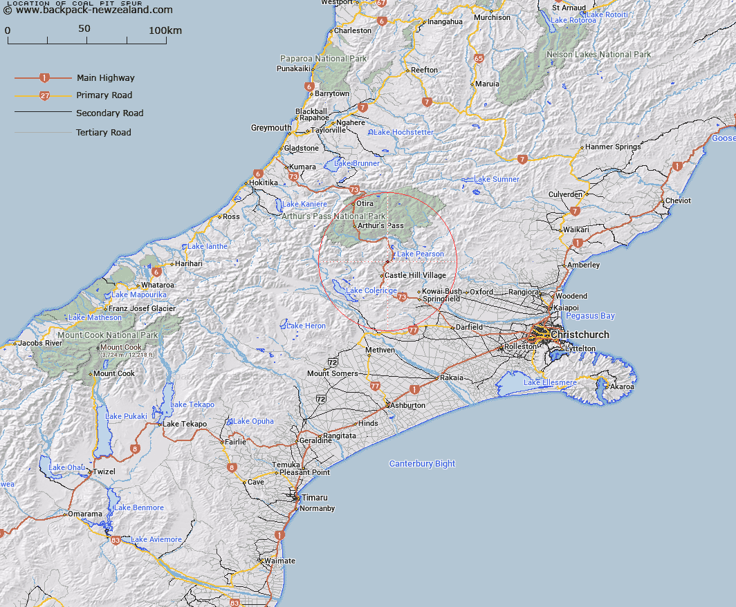
Map showing location of Coal Pit Spur


LINZ description: Spur on west side of West Coast Road south of Lake Pearson opposite Flock Hill Homestead
Latitude: -43.132572
Longitude: 171.751505
Northing: 5223706.7
Easting: 1498455.8
Land District: Canterbury
Feat Type: Ridge


Scroll down to see a more detailed road map and below that a topographical map showing the location of Coal Pit Spur. The road map has been supplied by openstreetmap and the topographical map of Coal Pit Spur has been supplied by Land Information New Zealand (LINZ).

Yes you can use the top static map for you school/university project or personal website with a link back. Contact me for any commercial use.

Coal Pit Spur Map New Zealand


New Zealand places in our database
[ A ] [ B ] [ C ] [ D ] [ E ] [ F ] [ G ] [ H ] [ I ] [ J ] [ K ] [ L ] [ M ] [ N ] [ O ] [ P ] [ Q ] [ R ] [ S ] [ T ] [ U ] [ V ] [ W ] [ X ] [ Y ] [ Z ]


Closest 20 Ridges to Coal Pit Spur

Long Spur ( 11.16km )   Lansdowne Spur ( 12.2km )   Dead Man Spur ( 13.52km )   Foggy Peak Ridge ( 17.13km )   Junction Spur ( 18.34km )   Blind Spur ( 18.78km )   Kowai Bush Spur ( 20.18km )   Hut Spur ( 20.27km )   Little Jordan Spur ( 21.35km )   The Spurs ( 23.53km )   Blackball Ridge ( 25.29km )   Rome Ridge ( 29.23km )   Jellicoe Ridge ( 29.99km )   Goldney Ridge ( 30.72km )   Camp Spur ( 31.48km )   Barron Ridge ( 36.58km )   Rosamond Ridge ( 36.89km )   Cairn Ridge ( 36.91km )   Hunts Ridge ( 37.17km )   Cabot Ridge ( 38.84km )   Reeses Ridge ( 39.81km )   Marshall Ridge ( 40.03km )   Marshal Ridge ( 40.03km )   Donovan Ridge ( 41.28km )   Homebush Ridge ( 41.42km )   Eliott Ridge ( 41.82km )   Eliot Ridge ( 41.82km )   Bald Hills ( 42.9km )   The Panhandle ( 45.7km )   Golden Spur ( 46.58km )   Brunswick Ridge ( 47.11km )   Whitehorn Ridge ( 47.73km )   Commodore Ridge ( 47.76km )   Razorback Ridge ( 47.91km )   Treachery Ridge ( 49.24km )   Homeward Ridge ( 49.55km )   Adventure Ridge ( 51.58km )   Clay Spurs ( 51.84km )   Long Spur ( 52.03km )   Yeats Ridge ( 52.2km )