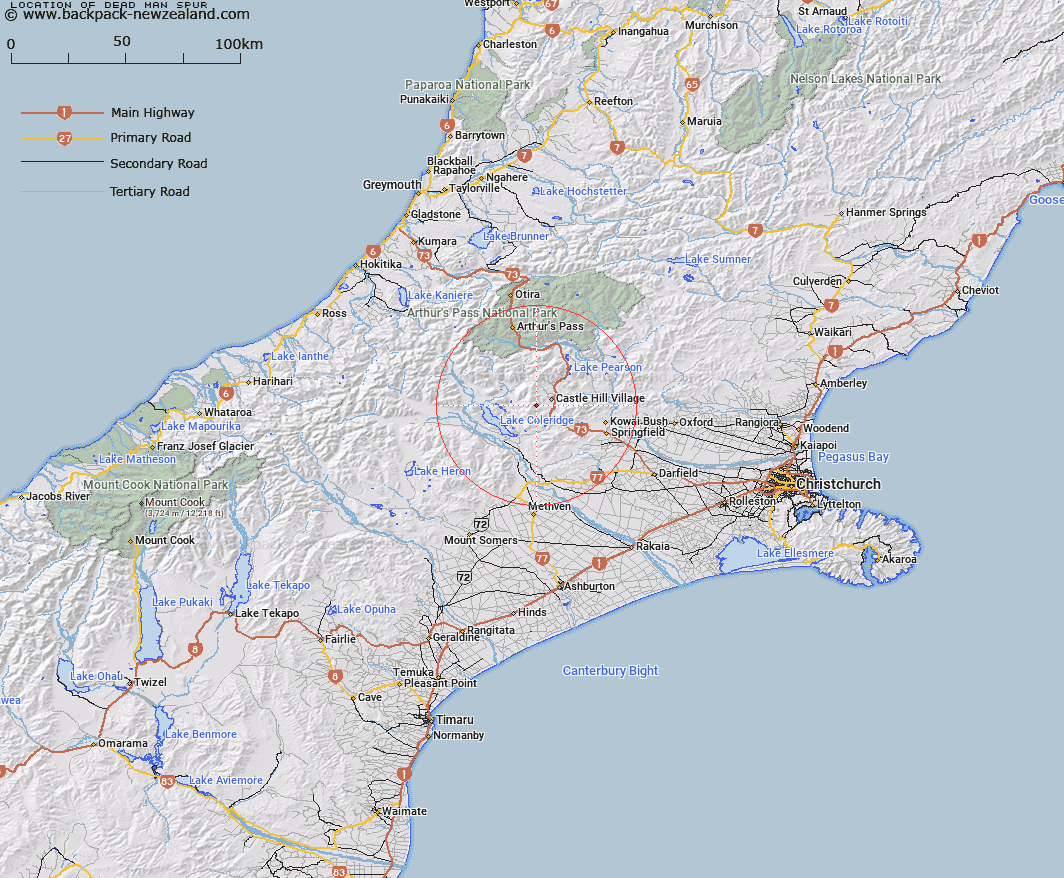
Map showing location of Dead Man Spur


LINZ description: Spur running north-east from Cam Brea to Whitewater Stream, a tributary of Porter River
Latitude: -43.23289
Longitude: 171.657223
Northing: 5212447.4
Easting: 1490966.1
Land District: Canterbury
Feat Type: Ridge


Scroll down to see a more detailed road map and below that a topographical map showing the location of Dead Man Spur. The road map has been supplied by openstreetmap and the topographical map of Dead Man Spur has been supplied by Land Information New Zealand (LINZ).

Yes you can use the top static map for you school/university project or personal website with a link back. Contact me for any commercial use.

Dead Man Spur Map New Zealand


New Zealand places in our database
[ A ] [ B ] [ C ] [ D ] [ E ] [ F ] [ G ] [ H ] [ I ] [ J ] [ K ] [ L ] [ M ] [ N ] [ O ] [ P ] [ Q ] [ R ] [ S ] [ T ] [ U ] [ V ] [ W ] [ X ] [ Y ] [ Z ]


Closest 20 Ridges to Dead Man Spur

Long Spur ( 3.01km )   Foggy Peak Ridge ( 9.48km )   Coal Pit Spur ( 13.52km )   Lansdowne Spur ( 15.23km )   The Spurs ( 18.36km )   Kowai Bush Spur ( 19.87km )   Junction Spur ( 20.89km )   Blind Spur ( 22.41km )   Hut Spur ( 23.96km )   Little Jordan Spur ( 24.26km )   Cairn Ridge ( 31.85km )   Camp Spur ( 33.93km )   Jellicoe Ridge ( 35.34km )   Rome Ridge ( 35.95km )   Golden Spur ( 36.61km )   Homebush Ridge ( 37.12km )   Cabot Ridge ( 37.3km )   Blackball Ridge ( 37.39km )   Goldney Ridge ( 37.54km )   Rosamond Ridge ( 38.67km )   Eliott Ridge ( 39.1km )   Eliot Ridge ( 39.1km )   Reeses Ridge ( 39.99km )   Marshall Ridge ( 41.02km )   Marshal Ridge ( 41.02km )   Centre Spur ( 41.11km )   Donovan Ridge ( 42.87km )   Hunts Ridge ( 43.27km )   Barron Ridge ( 43.53km )   Brunswick Ridge ( 43.54km )   Long Spur ( 43.84km )   Treachery Ridge ( 44.14km )   Homeward Ridge ( 45.73km )   Commodore Ridge ( 45.75km )   Ricki Spur ( 46.59km )   Whitehorn Ridge ( 48km )   Conway Ridge ( 48.25km )   Adventure Ridge ( 50.02km )   Bald Hills ( 50.13km )   Yeats Ridge ( 50.45km )