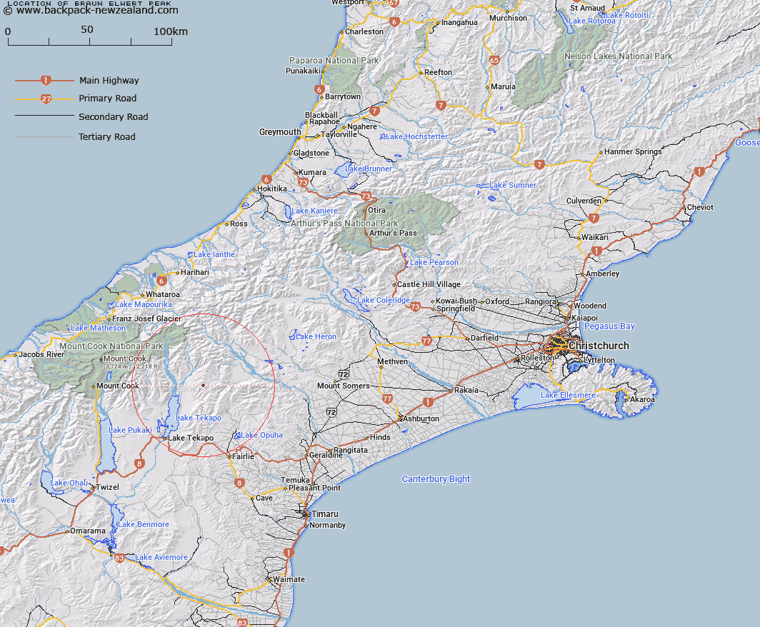
Map showing location of Braun-Elwert Peak


LINZ description: Located just south of Mount Hope in Two Thumb Range, at height 2086m. NZTopo50 BX17-Mount Sibbald, GR 141 556.
Latitude: -43.729574
Longitude: 170.691782
Northing: 5155572.9
Easting: 1414099.9
Land District: Canterbury
Feat Type: Hill


Scroll down to see a more detailed road map and below that a topographical map showing the location of Braun-Elwert Peak. The road map has been supplied by openstreetmap and the topographical map of Braun-Elwert Peak has been supplied by Land Information New Zealand (LINZ).

Yes you can use the top static map for you school/university project or personal website with a link back. Contact me for any commercial use.

Braun-Elwert Peak Map New Zealand


New Zealand places in our database
[ A ] [ B ] [ C ] [ D ] [ E ] [ F ] [ G ] [ H ] [ I ] [ J ] [ K ] [ L ] [ M ] [ N ] [ O ] [ P ] [ Q ] [ R ] [ S ] [ T ] [ U ] [ V ] [ W ] [ X ] [ Y ] [ Z ]


Closest 20 Hills to Braun-Elwert Peak

Mount Hope ( 0.44km )   Beuzenberg Peak ( 1.6km )   Mount Gerald ( 5.13km )   Mount Toby ( 6.46km )   Neutral Hill ( 7.73km )   Mount Musgrave ( 8.34km )   Captains Peak ( 9.78km )   Round Hill ( 10.16km )   Mount Pattisson ( 11.58km )   Observation Hill ( 12.02km )   High Terrace ( 12.76km )   Paris ( 12.82km )   Mount Misery ( 13.28km )   Mount Caton ( 13.6km )   Fox Peak ( 14.15km )   Mount Sinclair ( 14.22km )   Split Peaks ( 14.32km )   Electra Peak ( 15.19km )   Mount Ross ( 15.28km )   Sibbald Knobs ( 15.29km )   The Thumbs ( 15.43km )   Mount Erebus ( 16.04km )   Pikes Peak ( 16.34km )   Tantalus ( 16.42km )   Mistake Peak ( 16.8km )   Mount Brabazon ( 16.88km )   Priam ( 16.93km )   Ajax Peak ( 16.94km )   Myrmidon ( 17.44km )   Kea Knob ( 17.83km )   High Peak ( 18.04km )   Mount Chevalier ( 18.14km )   Achilles Peak ( 18.2km )   Sugar Loaf ( 18.3km )   Low Peak ( 18.52km )   Exeter Peak ( 19.56km )   Alma ( 19.61km )   Charlies Knob ( 20.08km )   Black Mountain ( 20.25km )   Mount Radove ( 20.85km )