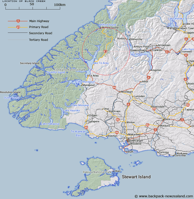
Map showing location of Black Creek


LINZ description: Stream flowing into Eglinton River West Branch, joining that river on the left bank, 1.5km upstream of the East/ West Branch Eglinton junction.
Latitude: -45.034958
Longitude: 168.009128
Northing: 5001036.5
Easting: 1206882.6
Land District: Southland
Feat Type: Stream


Scroll down to see a more detailed road map and below that a topographical map showing the location of Black Creek. The road map has been supplied by openstreetmap and the topographical map of Black Creek has been supplied by Land Information New Zealand (LINZ).

Yes you can use the top static map for you school/university project or personal website with a link back. Contact me for any commercial use.

Black Creek Map New Zealand


New Zealand places in our database
[ A ] [ B ] [ C ] [ D ] [ E ] [ F ] [ G ] [ H ] [ I ] [ J ] [ K ] [ L ] [ M ] [ N ] [ O ] [ P ] [ Q ] [ R ] [ S ] [ T ] [ U ] [ V ] [ W ] [ X ] [ Y ] [ Z ]


Closest 20 Streams to Black Creek

Wesney Creek ( 3.55km )   Annear Creek ( 4.99km )   Mackay Creek ( 5.35km )   Kiosk Creek ( 5.53km )   Eglinton River West Branch ( 7.72km )   Eglinton River East Branch ( 8.28km )   Nurse Creek ( 8.31km )   Smithy Creek ( 9.42km )   Murcott Burn ( 9.95km )   Walker Creek ( 10.02km )   Eglinton River ( 11.59km )   Windon Burn ( 12.34km )   Winton Burn ( 12.34km )   Boyd Creek ( 12.45km )   Mararoa River ( 12.92km )   Waterfall Creek ( 13.52km )   Glade Burn ( 13.67km )   Plato Creek ( 13.91km )   Billy Burn ( 15.26km )   Hut Creek ( 15.34km )   Cascade Creek ( 15.8km )   Hen Burn ( 15.96km )   Clinton River ( 17.31km )   Mistake Creek ( 17.35km )   Dunton Creek ( 17.69km )   Pond Burn ( 17.91km )   Saints Creek ( 18.27km )   Indecision Creek ( 18.45km )   Greenstone River ( 18.63km )   Pass Burn ( 19.51km )   McQueen Creek ( 19.62km )   Melita Stream ( 20.1km )   Narrows Creek ( 20.52km )   Steele Creek ( 20.53km )   Duck Creek ( 20.55km )   Sly Burn ( 20.55km )   Retford Stream ( 21.07km )   McKellar Branch;Greenstone River ( 21.08km )   West Burn ( 21.3km )   Trench Burn ( 21.79km )