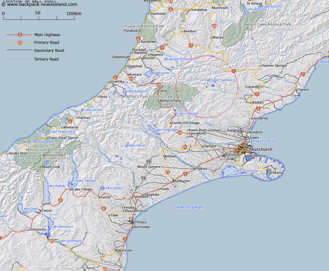
Map showing location of Bell Knoll


LINZ description: A small hill overlooking the Hurunui River on the east bank of the South Branch, south of Lake Sumner, opposite the original Esk Head homestead.
Latitude: -42.775113
Longitude: 172.164937
Northing: 5263820
Easting: 1531687.5
Land District: Canterbury
Feat Type: Hill


Scroll down to see a more detailed road map and below that a topographical map showing the location of Bell Knoll. The road map has been supplied by openstreetmap and the topographical map of Bell Knoll has been supplied by Land Information New Zealand (LINZ).

Yes you can use the top static map for you school/university project or personal website with a link back. Contact me for any commercial use.

Bell Knoll Map New Zealand


New Zealand places in our database
[ A ] [ B ] [ C ] [ D ] [ E ] [ F ] [ G ] [ H ] [ I ] [ J ] [ K ] [ L ] [ M ] [ N ] [ O ] [ P ] [ Q ] [ R ] [ S ] [ T ] [ U ] [ V ] [ W ] [ X ] [ Y ] [ Z ]


Closest 20 Hills to Bell Knoll

Island Hills ( 4.56km )   Mount Crossley ( 6.23km )   Conical Hill ( 6.85km )   Terrible Knob ( 9.18km )   Dampier Corner ( 10.72km )   Isolated Hill ( 11.31km )   Little Sisters ( 11.51km )   Esk Head ( 11.58km )   Macs Knob ( 11.59km )   Top of the Ladder ( 11.68km )   Dinner Hill ( 12.18km )   Niggerhead ( 12.34km )   Tawhai Hill ( 12.34km )   Mount Turnbull ( 12.51km )   Cherry Tree Hill ( 12.69km )   Mount Longfellow ( 13.81km )   Blake Peak ( 14.89km )   Mount Emerson ( 15.46km )   Shingle Hill ( 16.26km )   Mount Edison ( 17.41km )   Lookout Peak ( 17.57km )   Jollie Brook ( 18.49km )   Mount Miza ( 19.25km )   Big Flora ( 19.29km )   Howitt Peak ( 19.33km )   Neschacker Hill ( 19.36km )   Mons Boreas ( 19.37km )   Ben Cliberick ( 19.47km )   Virginia Peak ( 19.53km )   Mount Meehan ( 19.55km )   Poulter Hill ( 19.57km )   The Monument ( 19.71km )   Mount Row ( 20.06km )   Mount Whatno ( 20.12km )   Mount Tuke ( 20.14km )   Mount Pan ( 20.31km )   Ashley Head ( 20.86km )   Mount Noble ( 21.14km )   Mount Stapp ( 21.44km )   Devils Den ( 21.51km )