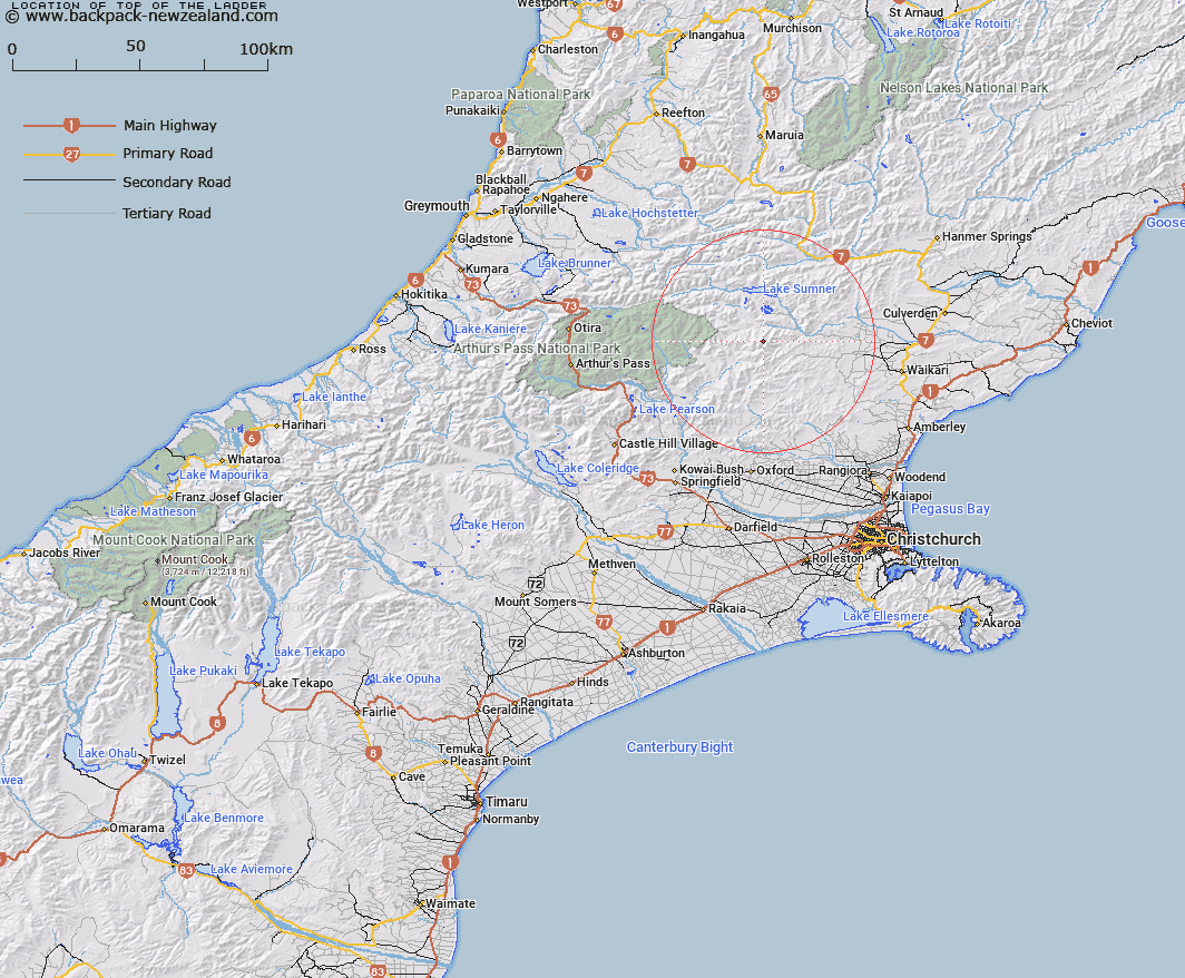
Map showing location of Top of the Ladder


LINZ description: Peak on the Dampier Range above Valley Stream, at the junction of a spur and the main range.
Latitude: -42.868083
Longitude: 172.231704
Northing: 5253548
Easting: 1537243.5
Land District: Canterbury
Feat Type: Hill


Scroll down to see a more detailed road map and below that a topographical map showing the location of Top of the Ladder. The road map has been supplied by openstreetmap and the topographical map of Top of the Ladder has been supplied by Land Information New Zealand (LINZ).

Yes you can use the top static map for you school/university project or personal website with a link back. Contact me for any commercial use.

Top of the Ladder Map New Zealand


New Zealand places in our database
[ A ] [ B ] [ C ] [ D ] [ E ] [ F ] [ G ] [ H ] [ I ] [ J ] [ K ] [ L ] [ M ] [ N ] [ O ] [ P ] [ Q ] [ R ] [ S ] [ T ] [ U ] [ V ] [ W ] [ X ] [ Y ] [ Z ]


Closest 20 Hills to Top of the Ladder

Esk Head ( 0.74km )   Island Hills ( 7.17km )   Dampier Corner ( 7.59km )   Mount Meehan ( 8.07km )   Mount Whatno ( 8.45km )   The Monument ( 8.78km )   Virginia Peak ( 9.05km )   Ashley Head ( 10km )   Cherry Tree Hill ( 10.53km )   Devils Den ( 10.64km )   Conical Hill ( 11.08km )   Mount Crossley ( 11.25km )   Bell Knoll ( 11.68km )   Little Sisters ( 12.27km )   Gola Peak ( 12.86km )   Mount Noble ( 12.95km )   Block Hill ( 13.79km )   Mount Miza ( 14.34km )   Mount Turnbull ( 14.59km )   Shingle Hill ( 15.1km )   Tower Hill ( 15.31km )   Ben Cliberick ( 15.69km )   Mount Gordon ( 15.72km )   Madrid Hill ( 16km )   Big Flora ( 16.28km )   Little Flora ( 16.98km )   Surveyors Knob ( 17.09km )   Seven Hills ( 17.71km )   Cloudy Hill ( 17.84km )   Mount Oval ( 17.89km )   Mons Boreas ( 18.49km )   Double Tops ( 18.7km )   Spring Hill ( 18.75km )   Poulter Hill ( 19.35km )   Lillburn Hill ( 19.39km )   Lilburne Hill ( 19.39km )   Nigger Hill ( 19.81km )   K?nuka Hills ( 19.81km )   Mount Longfellow ( 20.16km )   Jollie Brook ( 20.25km )