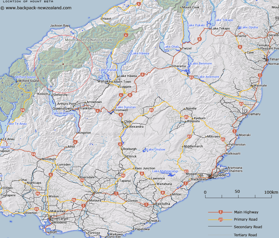
Map showing location of Mount Beta


LINZ description: On snowdrift Range
Latitude: -44.45678
Longitude: 168.537849
Northing: 5067700
Easting: 1245000
Land District: Otago
Feat Type: Hill


Scroll down to see a more detailed road map and below that a topographical map showing the location of Mount Beta. The road map has been supplied by openstreetmap and the topographical map of Mount Beta has been supplied by Land Information New Zealand (LINZ).

Yes you can use the top static map for you school/university project or personal website with a link back. Contact me for any commercial use.

Mount Beta Map New Zealand


New Zealand places in our database
[ A ] [ B ] [ C ] [ D ] [ E ] [ F ] [ G ] [ H ] [ I ] [ J ] [ K ] [ L ] [ M ] [ N ] [ O ] [ P ] [ Q ] [ R ] [ S ] [ T ] [ U ] [ V ] [ W ] [ X ] [ Y ] [ Z ]


Closest 20 Hills to Mount Beta

Alpha Mountain ( 0.32km )   Gamma Mountain ( 0.4km )   The Snowman Peak ( 0.73km )   Delta Mountain ( 0.8km )   Mount Troas ( 2.31km )   Pivot Peak ( 2.5km )   Mount Lydia ( 2.71km )   Marion Tower ( 2.84km )   Humboldt Tower ( 3.34km )   Mount Amundsen ( 3.61km )   Mount Maoriori ( 3.8km )   Mount Maoriri ( 3.8km )   Mount Edward ( 3.87km )   Key Dome ( 3.88km )   Mount Tiber ( 4.68km )   Mount Maruiwi ( 4.68km )   Mount Ian ( 5.79km )   Maiti-iti ( 5.84km )   Bernard Peak ( 6.2km )   Mount Maori ( 6.21km )   Mount Victoria ( 6.63km )   Mount Wahine ( 6.7km )   Ferrier Peak ( 6.78km )   Plunket Dome ( 7.11km )   Mount Liverpool ( 7.45km )   Islington Dome ( 7.67km )   Five Fingers ( 8.04km )   Mount Ansted ( 8.46km )   Cilicia Peak ( 8.56km )   Mount Caria ( 8.74km )   Camp Oven Dome ( 8.83km )   Mount Cunningham ( 9.01km )   Turks Head ( 9.57km )   Athene Mountain ( 9.57km )   Frobisher Mountain ( 9.59km )   Pyramid ( 9.63km )   Headlong Peak ( 10.16km )   Bow Peak ( 10.19km )   Mount Peary ( 10.24km )   Mount Ionia ( 10.36km )