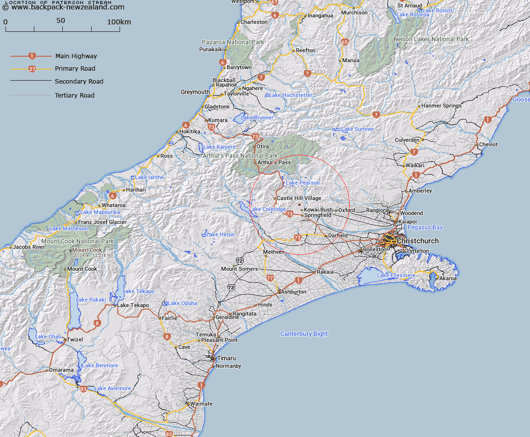
Map showing location of Paterson Stream


LINZ description: Stream flowing generally easterly into the Waimakariri River, located in the foothills above where the Waimakariri River enters the Canterbury Plains
Latitude: -43.254912
Longitude: 171.909708
Northing: 5210300
Easting: 1511500
Land District: Canterbury
Feat Type: Stream


Scroll down to see a more detailed road map and below that a topographical map showing the location of Paterson Stream. The road map has been supplied by openstreetmap and the topographical map of Paterson Stream has been supplied by Land Information New Zealand (LINZ).

Yes you can use the top static map for you school/university project or personal website with a link back. Contact me for any commercial use.

Paterson Stream Map New Zealand


New Zealand places in our database
[ A ] [ B ] [ C ] [ D ] [ E ] [ F ] [ G ] [ H ] [ I ] [ J ] [ K ] [ L ] [ M ] [ N ] [ O ] [ P ] [ Q ] [ R ] [ S ] [ T ] [ U ] [ V ] [ W ] [ X ] [ Y ] [ Z ]


Closest 20 Streams to Paterson Stream

Joyces Stream ( 1.15km )   Waterfall Creek ( 3.62km )   Waterfall Stream ( 3.62km )   Otarama Stream ( 4.57km )   Chasm Stream ( 4.6km )   Blakistons Stream ( 4.86km )   Truscotts Stream ( 5.35km )   Rocky Stream ( 5.63km )   Little Kowai River ( 5.63km )   Kinnebrooks Stream ( 5.85km )   Ede Stream ( 6.33km )   Foster Stream ( 6.7km )   Lansdowne Creek ( 6.86km )   Coal Creek ( 7.21km )   Rubicon River ( 7.87km )   Iron Creek ( 8.28km )   Eyre River ( 8.34km )   Nomans Stream ( 9.16km )   Ayrdale Stream ( 9.33km )   Emu Stream ( 9.41km )   White Stream ( 9.76km )   Puffers Stream ( 10.23km )   Blackley Stream ( 10.79km )   Milliken Stream ( 10.92km )   Dobson Stream ( 11.43km )   Foggy Stream ( 11.59km )   Adams Stream ( 11.76km )   Camp Stream ( 11.76km )   Kowai River ( 12.12km )   Townshend River ( 12.75km )   Flock Hill Stream ( 12.87km )   Broadleaf Stream ( 13.02km )   Ghost Creek ( 13.1km )   West Branch Coopers Creek ( 13.58km )   Winding Creek ( 13.61km )   Waimakariri River ( 13.81km )   Moody Stream ( 13.81km )   Mounseys Stream ( 13.89km )   Washpen Stream ( 13.89km )   Coach Stream ( 14km )