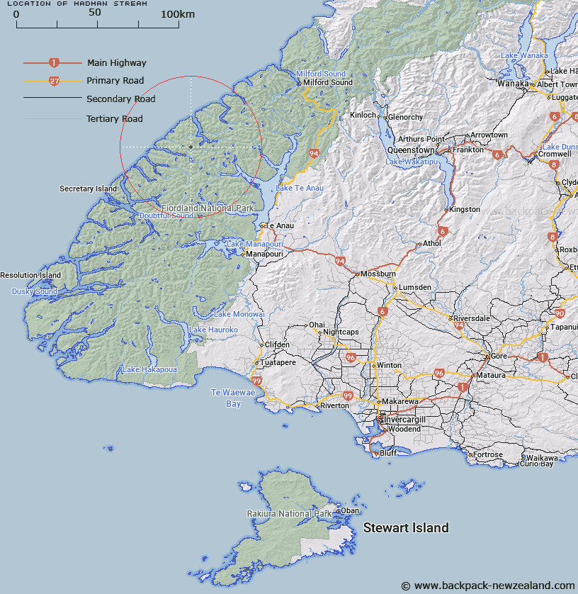
Map showing location of Madman Stream


LINZ description: North-east of Spot Hill Ridge between Caswell and George Sounds. Flows south-east into Stillwater River
Latitude: -45.003386
Longitude: 167.333725
Northing: 5001033
Easting: 1153437.1
Land District: Southland
Feat Type: Stream


Scroll down to see a more detailed road map and below that a topographical map showing the location of Madman Stream. The road map has been supplied by openstreetmap and the topographical map of Madman Stream has been supplied by Land Information New Zealand (LINZ).

Yes you can use the top static map for you school/university project or personal website with a link back. Contact me for any commercial use.

Madman Stream Map New Zealand


New Zealand places in our database
[ A ] [ B ] [ C ] [ D ] [ E ] [ F ] [ G ] [ H ] [ I ] [ J ] [ K ] [ L ] [ M ] [ N ] [ O ] [ P ] [ Q ] [ R ] [ S ] [ T ] [ U ] [ V ] [ W ] [ X ] [ Y ] [ Z ]


Closest 20 Streams to Madman Stream

Expectation Stream ( 2.39km )   Feldspar Stream ( 3.99km )   Ethne Stream ( 5.2km )   Whitewater River ( 6.61km )   Overlander Stream ( 6.64km )   Katherine Creek ( 8.64km )   Nita Creek ( 8.79km )   Large Burn ( 10.34km )   Trophy Burn ( 12.42km )   Stillwater River ( 12.62km )   Campbell Creek ( 13.42km )   Irene River ( 13.46km )   Edith River ( 13.87km )   Rugged Burn ( 14.91km )   West Burn ( 14.91km )   Juno River ( 15.06km )   George River ( 15.31km )   Pisgah Creek ( 15.58km )   Doon River ( 16.65km )   Barrier Stream ( 16.68km )   Wapiti River ( 16.87km )   Rugged Burn ( 16.87km )   McDonald Creek ( 17.29km )   Junction Burn ( 19.03km )   Canyon Creek ( 19.89km )   Jennings Burn ( 19.97km )   Pitt River ( 20.79km )   Midnight Creek ( 20.89km )   Windward River ( 21.32km )   Wild Natives River ( 22.69km )   McIvor Burn ( 22.75km )   Stina Burn ( 23.5km )   Woodrow Burn ( 23.97km )   Wisely Burn ( 24.59km )   Austral Creek ( 24.71km )   Bernard Burn ( 25.32km )   Inaccessible Creek ( 25.43km )   Taheke Creek ( 25.48km )   Henderson Burn ( 25.8km )   Misty River ( 26.41km )