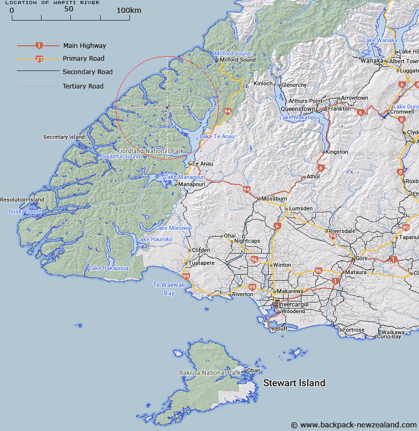
Map showing location of Wapiti River


LINZ description: Arising in the region of Lake Sutherland and flowing southerly through Lakes Thomson and Hankinson into the north-west arm of the Middle Fiord of Lake Te Anau
Latitude: -45.010803
Longitude: 167.548015
Northing: 5001371.4
Easting: 1170381
Land District: Southland
Feat Type: Stream


Scroll down to see a more detailed road map and below that a topographical map showing the location of Wapiti River. The road map has been supplied by openstreetmap and the topographical map of Wapiti River has been supplied by Land Information New Zealand (LINZ).

Yes you can use the top static map for you school/university project or personal website with a link back. Contact me for any commercial use.

Wapiti River Map New Zealand


New Zealand places in our database
[ A ] [ B ] [ C ] [ D ] [ E ] [ F ] [ G ] [ H ] [ I ] [ J ] [ K ] [ L ] [ M ] [ N ] [ O ] [ P ] [ Q ] [ R ] [ S ] [ T ] [ U ] [ V ] [ W ] [ X ] [ Y ] [ Z ]


Closest 20 Streams to Wapiti River

West Burn ( 2.19km )   Rugged Burn ( 2.19km )   Canyon Creek ( 3.42km )   Barrier Stream ( 4.48km )   Stillwater River ( 6.13km )   Edith River ( 6.23km )   Midnight Creek ( 6.82km )   Inaccessible Creek ( 8.57km )   Katherine Creek ( 8.69km )   Nita Creek ( 8.78km )   Austral Creek ( 8.93km )   Henderson Burn ( 9.29km )   George River ( 10.06km )   Pisgah Creek ( 10.54km )   Overlander Stream ( 10.57km )   Taheke Creek ( 10.65km )   Pitt River ( 10.72km )   Glaisnock River ( 11.39km )   Ethne Stream ( 11.69km )   Campbell Creek ( 11.71km )   Kakapo Creek ( 12.16km )   Lugar Burn ( 12.79km )   Doon River ( 13.37km )   McIvor Burn ( 13.76km )   Nitz Creek ( 14.01km )   Newton Creek ( 14.03km )   Wild Natives River ( 14.04km )   Mid Burn ( 14.62km )   McDonald Creek ( 14.7km )   Loch Burn ( 14.76km )   Trophy Burn ( 15.11km )   Bernard Burn ( 15.2km )   Large Burn ( 15.41km )   Tertiary Creek ( 15.95km )   Feldspar Stream ( 16.05km )   Narrows Creek ( 16.16km )   Madman Stream ( 16.87km )   Worsley Stream ( 17.13km )   Junction Burn ( 17.38km )   Whitewater River ( 18.19km )