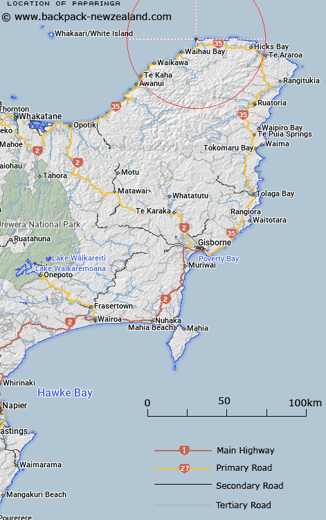
Map showing location of Paparinga


LINZ description: At Cape Runaway NZ Topo50 BD43, at height 295m Geodetic code B129.
Latitude: -37.544701
Longitude: 177.986066
Northing: 5833000
Easting: 2040600
Land District: Gisborne
Feat Type: Trig Station


Scroll down to see a more detailed road map and below that a topographical map showing the location of Paparinga. The road map has been supplied by openstreetmap and the topographical map of Paparinga has been supplied by Land Information New Zealand (LINZ).

Yes you can use the top static map for you school/university project or personal website with a link back. Contact me for any commercial use.

Paparinga Map New Zealand


New Zealand places in our database
[ A ] [ B ] [ C ] [ D ] [ E ] [ F ] [ G ] [ H ] [ I ] [ J ] [ K ] [ L ] [ M ] [ N ] [ O ] [ P ] [ Q ] [ R ] [ S ] [ T ] [ U ] [ V ] [ W ] [ X ] [ Y ] [ Z ]


Closest 20 Trig Stations to Paparinga

Otiki ( 48km )   Tokiameha ( 52.78km )   Pokiameha ( 52.78km )   Puhikereru ( 54.29km )   Pukekeruru ( 54.29km )   Ratahi ( 57.88km )   Ratatahi ( 57.88km )   Meringahei ( 60.15km )   Miringahei ( 60.15km )   Tarakeha ( 68.24km )   Tarakeho ( 68.24km )   Te Atuahautapu ( 69.79km )   Te Atua Ahutapu ( 69.79km )   Ngawhenga ( 72.21km )   Ngawehenga ( 72.21km )   Te Pakora ( 72.51km )   Te Pakera ( 72.51km )   Pukekiore ( 74.75km )   Tawhitiapaka ( 75.63km )   Tawhiti ( 75.63km )   Tutamoi ( 76.75km )   Tutamoe ( 76.75km )   Hamutuni ( 76.84km )   Hamutinui ( 76.84km )   Te Iwi Roa ( 80.41km )   Te Iwiroa ( 80.41km )   Paripoupou ( 84.53km )   Parepoupou ( 84.53km )   Maungahunia ( 88.61km )   Maungahaumi ( 88.61km )   Mangahaumia ( 88.61km )   Pataua ( 91.76km )   Patawa ( 91.76km )   Motuhora ( 92.33km )   Moutohora ( 92.33km )   Maungawhiorangi ( 95.72km )   Tapapanui ( 108.92km )   Taumatamiere ( 119.53km )   Taumatamiri ( 119.53km )   Ngapuketurua ( 122.88km )