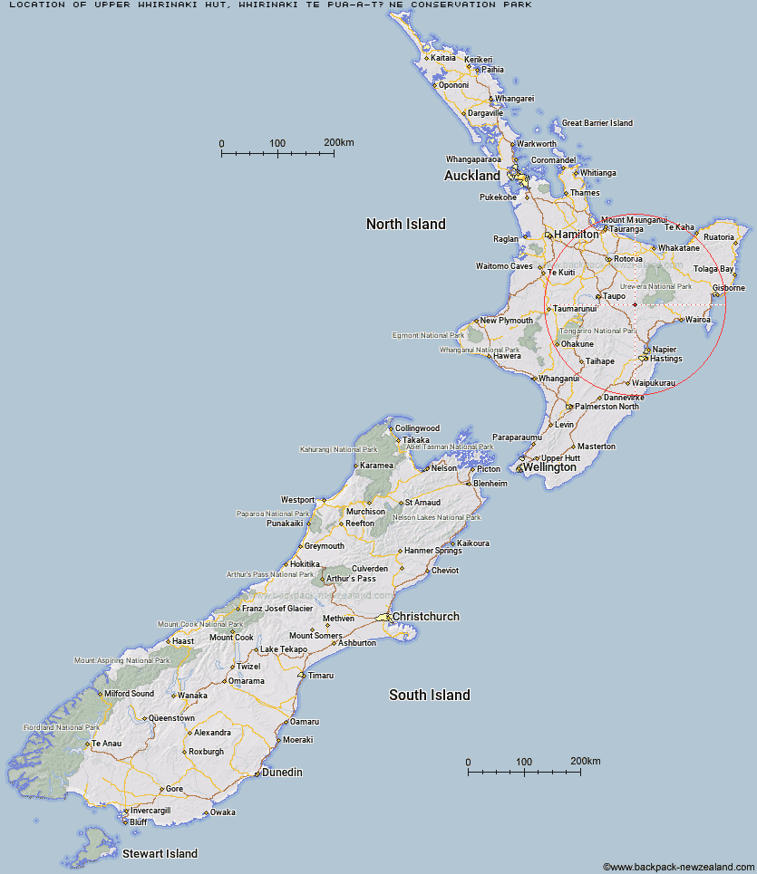
Topo Map showing location of Upper Whirinaki Hut
This information is sourced from DoC, LINZ and Openstreetmap. Some of the hut photos are mine and the rest are from DoC. I will be adding an upload feature soon so people can photos of .Upper Whirinaki Hut.
Basic info: A very popular hut for hunters, this is a standard nine-bunk hut.
Latitude: -38.8125311036
Longitude: 176.672955508
Location: Whirinaki Te Pua-a-Tāne Conservation Park
Area: East Coast
Type of Hut: Standard
Tracks: Whirinaki Track
Map: BG38 Topo Map | Road Map
Does this hut still exist? Have any more information? Contact
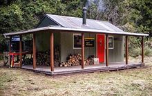
Image: DoC
Scroll down to see a topographical map and road map showing the location of Upper Whirinaki Hut
[ A ] [ B ] [ C ] [ D ] [ E ] [ F ] [ G ] [ H ] [ I ] [ J ] [ K ] [ L ] [ M ] [ N ] [ O ] [ P ] [ Q ] [ R ] [ S ] [ T ] [ U ] [ V ] [ W ] [ Y ] [ Z ]
Closest 20 Huts to Upper Whirinaki Hut
These are as the crow fliesCentral Whirinaki Hut 4.96km Upper Te Hoe Hut 5.08km Mangamate Hut 6.46km Moerangi Hut 8.42km Mangakahika Hut 8.67km Vern's Camp Shelter 10.09km Central Te Hoe Hut 10.11km Upper Matakuhia Hut 11.29km Rogers Hut (Te Wairoa) 12.08km Halfway Hut 14.63km Lower Matakuhia Hut 14.96km Skips Hut (Whangatawhia) 15.03km Central Waiau Hut 15.87km Te Waiotukapiti Hut 15.87km Te Totara Hut 19.62km Lower Ohane Hut 26.75km Waiopaoa Hut 27.82km Marauiti Hut 28.43km Whakatakaa Hut 31.46km Waiharuru Hut 32.1km Panekire Hut 32.82km Okui Hut 33.36km Whanganui Hut 33.43km Upper Toropapa Hut 33.47km Mangapouri Hut 33.66km Galbraith Hut 37.67km Kanohirua Hut 38.38km Upper Ripia Hut 38.7km Ernie's Creek Hut 39.29km Lower Ripia Hut 39.58km Tevers Hut 40.23km Te Matai Hut 40.77km Manuoha Hut 42.56km Waiawa Hut 42.58km Tawhiwhi Hut 43.24km Red Hut 43.28km Ngahiramai Hut 44.36km Poronui Hut 44.68km East Creek Hut 45.05km Oamaru Hut 45.84km