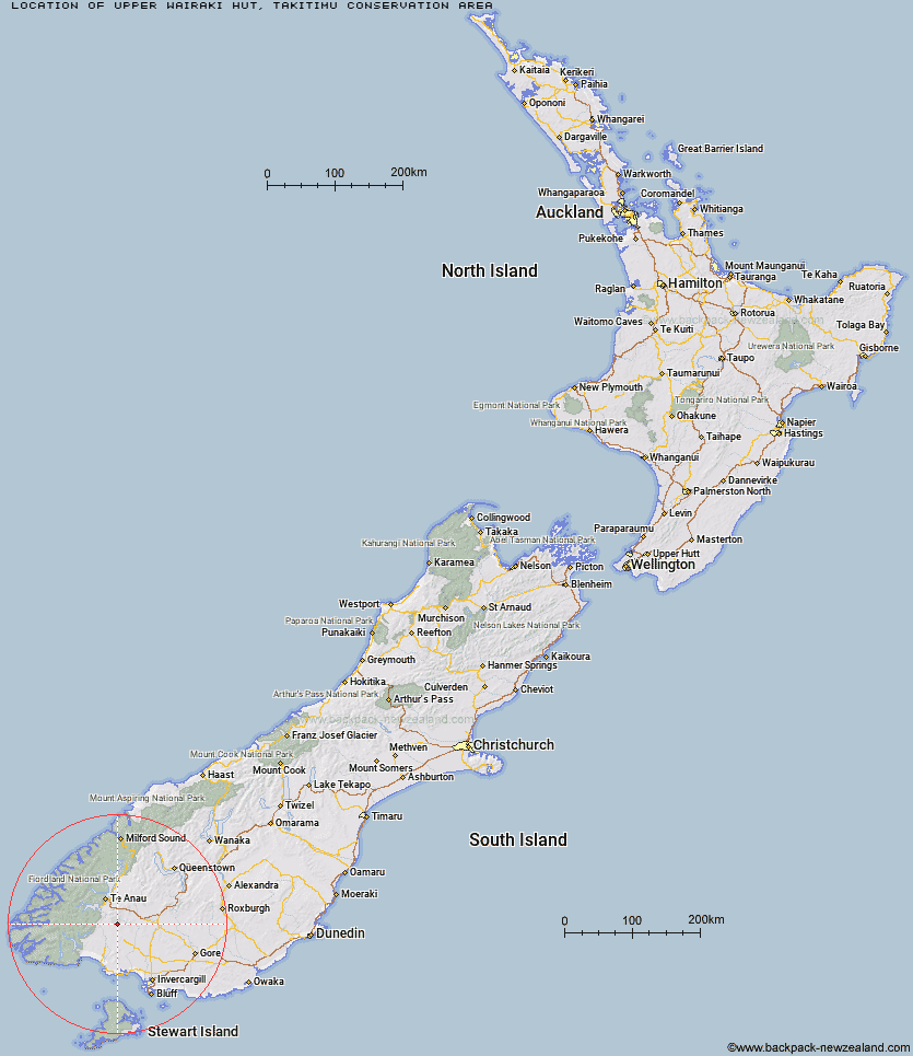
Topo Map showing location of Upper Wairaki Hut
This information is sourced from DoC, LINZ and Openstreetmap. Some of the hut photos are mine and the rest are from DoC. I will be adding an upload feature soon so people can photos of .Upper Wairaki Hut.
Basic info: basic two-bunk hut in the Southland area.
Latitude: -45.7349500211
Longitude: 167.889309168
Location: Takitimu Conservation Area
Area: Southland
Type of Hut: Basic/bivvies
Tracks: Takitimu Mountains tracks and routes
Map: CE08 Topo Map | Road Map
Does this hut still exist? Have any more information? Contact
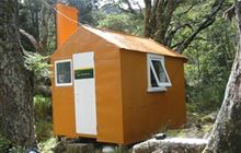
Image: DoC
Scroll down to see a topographical map and road map showing the location of Upper Wairaki Hut
[ A ] [ B ] [ C ] [ D ] [ E ] [ F ] [ G ] [ H ] [ I ] [ J ] [ K ] [ L ] [ M ] [ N ] [ O ] [ P ] [ Q ] [ R ] [ S ] [ T ] [ U ] [ V ] [ W ] [ Y ] [ Z ]
Closest 20 Huts to Upper Wairaki Hut
These are as the crow fliesUpper Wairaki Hut 0km Spence Hut 3.37km Telford Hut 3.88km Redcliff Hut 5.08km Lower Wairaki Hut 6.36km Aparima Forks Hut 7.75km Whare Creek Hut 8.91km Aparima Huts 9.07km Rock Hut 11.37km Becketts Hut 12.51km Upper Princhester Hut 12.67km Barcoo Hut 13.96km Cheviot Downs Hut 13.99km Lower Princhester Hut 16.44km Back Valley Hut 28.21km Hope Arm Hut 31.48km North Borland Hut 31.78km Oreti Hut 33.67km Shallow Bay Hut 34.42km Lower Windley Hut 34.82km Moturau Hut 35.53km Rodger Inlet Huts 37.17km Green Lake Hut 38.37km Borland Bivouac 40.2km Brod Bay Shelter and Campsite 40.35km Cromel Base Hut 42.24km Islands Hut 43km Upper Windley Hut 43.11km Monowai Hut 43.3km Clark Hut - A Frame 43.75km Eel Creek Hut 44.06km Luxmore Hut 44.2km Mt Bee Bunkrooms 44.21km Historic Clark Hut 44.62km Kiwi Burn Hut 45.06km Lincoln Hut 45.18km Forest Burn Shelter 45.68km Cromel Branch Hut 46.77km Percy Shelter 46.85km Upper Cromel Hut 46.86km