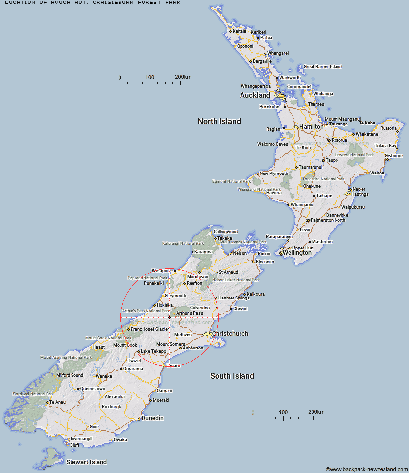
Topo Map showing location of Avoca Hut
This information is sourced from DoC, LINZ and Openstreetmap. Some of the hut photos are mine and the rest are from DoC. I will be adding an upload feature soon so people can photos of .Avoca Hut.
Basic info: basic six-bunk hut in the North Canterbury and Arthur's Pass area.
Latitude: -43.0532205504
Longitude: 171.430194361
Location: Craigieburn Forest Park
Area: Canterbury
Type of Hut: Basic/bivvies
Map: BV20 Topo Map | Road Map
Does this hut still exist? Have any more information? Contact
Basic info: basic six-bunk hut in the North Canterbury and Arthur's Pass area.
Latitude: -43.0532205504
Longitude: 171.430194361
Location: Craigieburn Forest Park
Area: Canterbury
Type of Hut: Basic/bivvies
Map: BV20 Topo Map | Road Map
Does this hut still exist? Have any more information? Contact
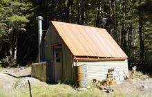
Image: DoC
Scroll down to see a topographical map and road map showing the location of Avoca Hut
[ A ] [ B ] [ C ] [ D ] [ E ] [ F ] [ G ] [ H ] [ I ] [ J ] [ K ] [ L ] [ M ] [ N ] [ O ] [ P ] [ Q ] [ R ] [ S ] [ T ] [ U ] [ V ] [ W ] [ Y ] [ Z ]
Closest 20 Huts to Avoca Hut
These are as the crow fliesBack Basin Hide 3.77km Old Basins Hut 6.59km Basins Hut 6.66km Weka Burnet Bivouac 7.48km Barker Hut 7.62km Anti Crow Hut 8.89km Urquhart's Hut 9.44km Fanghill Hut 9.6km Carrington Hut 10.48km Moa Hut 10.73km Park Morpeth Hut 11.55km Bealey Spur Hut 11.57km Unknown Stream Hut 12.8km Lagoon Saddle Hut 13.88km Lagoon Saddle A Frame Hut 13.94km Crow Hut 14.1km Klondyke Shelter 14.11km Manuels Hut 14.55km Greyneys Shelter 15.1km West Harper Hut 15.27km Waimakariri Falls Hut 15.79km Moa Stream Hut 16.15km Bealey Hut 17.27km Old Julia Hut 17.27km Harman Hut 17.29km Julia Hut 17.31km Top Crawford Hut 17.98km Jacks Hut 18.18km Campbell Bivouac 18.24km Hamilton Hut 18.3km Crawford Junction Hut 18.97km Mungo Hut 19.16km Mudflats Hut 20.48km Browning Range Bivouac 20.73km Top Kokatahi Hut 21.1km Grassy Flat Hut 21.14km Edwards Hut 21.61km Mingha Bivouac 21.78km Toaroha Saddle Bivouac 21.82km Cass Saddle Hut 21.82km