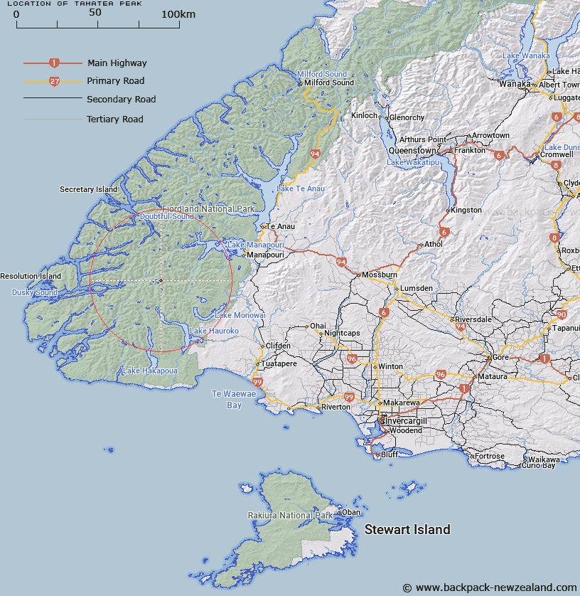
Map showing location of Tamatea Peak


LINZ description: The peak in the Merrie Range above and west of Dusky Sound. Height approximately 1634m (5360ft)
Latitude: -45.691954
Longitude: 167.168124
Northing: 4923613.1
Easting: 1145943.9
Land District: Southland
Feat Type: Hill


Scroll down to see a more detailed road map and below that a topographical map showing the location of Tamatea Peak. The road map has been supplied by openstreetmap and the topographical map of Tamatea Peak has been supplied by Land Information New Zealand (LINZ).

Yes you can use the top static map for you school/university project or personal website with a link back. Contact me for any commercial use.

Tamatea Peak Map New Zealand


New Zealand places in our database
[ A ] [ B ] [ C ] [ D ] [ E ] [ F ] [ G ] [ H ] [ I ] [ J ] [ K ] [ L ] [ M ] [ N ] [ O ] [ P ] [ Q ] [ R ] [ S ] [ T ] [ U ] [ V ] [ W ] [ X ] [ Y ] [ Z ]


Closest 20 Hills to Tamatea Peak

Vincent Peak ( 5.29km )   Mount Reeves ( 6.02km )   McDonnell Peak ( 7.36km )   Tripod Hill ( 8.43km )   Mount Ward ( 9.43km )   Mount Puteketeke ( 9.66km )   Mount McCorley ( 10.06km )   Mount Thompson ( 10.32km )   Aubrey Peak ( 10.81km )   Mount Memphis ( 11.11km )   Mount Chisholm ( 11.56km )   Mount Watson ( 11.58km )   Pinnacle ( 11.66km )   Mount Bain ( 11.66km )   Mount Fitchett ( 11.85km )   Heywood Peak ( 12.38km )   Kathryn Peak ( 12.5km )   Mount Menteath ( 13.07km )   Mount Solitary ( 13.12km )   Mount Pember ( 13.25km )   Mount Horatio ( 13.67km )   Mount Vera ( 14km )   Mount Thornton ( 14.4km )   Mount Parker ( 14.47km )   Sea View Peak ( 14.54km )   Mount Cusack ( 14.67km )   Mount Nantes ( 14.94km )   Mount Gladstone ( 15.23km )   Tussock Peak ( 15.76km )   Matterhorn ( 15.78km )   Mount Noble ( 15.93km )   Mount Grey ( 16.64km )   Mount Gray ( 16.64km )   Koinga Peak ( 18km )   Mount Crowfoot ( 18.17km )   Mount Crescent ( 18.93km )   End Peak ( 19.26km )   Black Giants ( 19.49km )   Mount Burns ( 19.53km )   Pahiri Peak ( 19.8km )