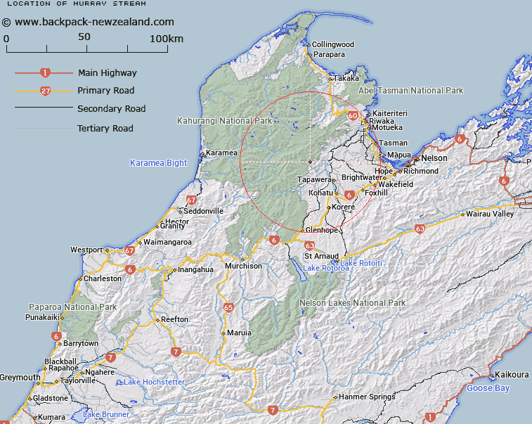
Map showing location of Murray Stream


LINZ description: Stream flowing easterly from the southern end of Paddy Ridge to join the Ellis River 1.6km upstream of Baton River. Block II Wangapeka Survey District.
Latitude: -41.287192
Longitude: 172.694115
Northing: 5429316
Easting: 1574386.6
Land District: Nelson
Feat Type: Stream


Scroll down to see a more detailed road map and below that a topographical map showing the location of Murray Stream. The road map has been supplied by openstreetmap and the topographical map of Murray Stream has been supplied by Land Information New Zealand (LINZ).

Yes you can use the top static map for you school/university project or personal website with a link back. Contact me for any commercial use.

Murray Stream Map New Zealand


New Zealand places in our database
[ A ] [ B ] [ C ] [ D ] [ E ] [ F ] [ G ] [ H ] [ I ] [ J ] [ K ] [ L ] [ M ] [ N ] [ O ] [ P ] [ Q ] [ R ] [ S ] [ T ] [ U ] [ V ] [ W ] [ X ] [ Y ] [ Z ]


Closest 20 Streams to Murray Stream

Hicky Creek ( 1.34km )   Ellis River ( 1.64km )   Baton River ( 2.47km )   Haines Stream ( 2.66km )   Long Gully Stream ( 3.05km )   White Creek ( 3.78km )   Bruce Creek ( 3.97km )   Stony Creek ( 4.22km )   Loveridge Creek ( 4.28km )   McCarthy Creek ( 4.67km )   Price Creek ( 5.13km )   Moran Creek ( 5.14km )   Naylor Creek ( 5.2km )   Skeet River ( 5.54km )   Ironstone Creek ( 6.34km )   Rocky Creek ( 6.91km )   McRae Creek ( 7.16km )   Field Creek ( 7.37km )   Goat Creek ( 7.9km )   Clarke River ( 8.26km )   Taylor Creek ( 8.27km )   Eyles Creek ( 8.34km )   Fowler Creek ( 8.42km )   Marble Arch Creek ( 8.93km )   Little Bacon Creek ( 9.04km )   Granity Creek ( 9.22km )   Coal Creek ( 9.26km )   Pearse River ( 9.29km )   Twins Creek ( 9.45km )   Arthur Creek ( 9.72km )   Blue Rock Creek ( 9.76km )   Bacon Creek ( 10.12km )   Waterfall Creek ( 10.13km )   Sugar Loaf Creek ( 10.14km )   Caves Creek ( 10.38km )   Whisky Creek ( 10.38km )   Little Crow River ( 11km )   Motueka River ( 11.08km )   Horseshoe Creek ( 11.3km )   Green Hill Creek ( 11.46km )