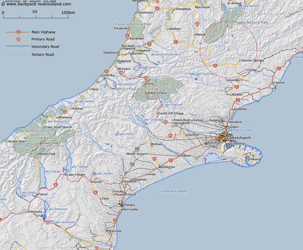
Map showing location of Mount Wilmer


LINZ description: Located in the St James Range, 20km north-west of Hanmer Springs, at height 1802m. NZTopo50 BT24-Ada Flat, GR 737 084.
Latitude: -42.376604
Longitude: 172.680629
Northing: 5308359.1
Easting: 1573707
Land District: Canterbury
Feat Type: Hill


Scroll down to see a more detailed road map and below that a topographical map showing the location of Mount Wilmer. The road map has been supplied by openstreetmap and the topographical map of Mount Wilmer has been supplied by Land Information New Zealand (LINZ).

Yes you can use the top static map for you school/university project or personal website with a link back. Contact me for any commercial use.

Mount Wilmer Map New Zealand


New Zealand places in our database
[ A ] [ B ] [ C ] [ D ] [ E ] [ F ] [ G ] [ H ] [ I ] [ J ] [ K ] [ L ] [ M ] [ N ] [ O ] [ P ] [ Q ] [ R ] [ S ] [ T ] [ U ] [ V ] [ W ] [ X ] [ Y ] [ Z ]


Closest 20 Hills to Mount Wilmer

Mount Pollock ( 1.5km )   Mount Sadd ( 2.57km )   Tonga Hill ( 2.72km )   Plinlimmon ( 3.62km )   Mount Maria ( 3.85km )   Mount Horrible ( 4.38km )   Birdcage ( 5.19km )   Mount Clara ( 5.21km )   Lookout Hill ( 6.09km )   Mount Catley ( 6.51km )   Mount Pickett ( 6.65km )   Mount Saint George ( 6.84km )   Samoa Mound ( 6.91km )   Red Hill ( 7.15km )   Mount Taliessin ( 7.38km )   Bunkers Hill ( 7.59km )   Mount Scott ( 7.84km )   Rabbit Hill ( 7.95km )   Lake Hill ( 8.24km )   Mount Douglas ( 8.51km )   Charlies Hill ( 8.53km )   Mount Laura ( 8.61km )   Mount Saint Patrick ( 8.65km )   San Jago ( 8.81km )   Peters Hill ( 9.87km )   Mount Seymour ( 9.99km )   Saint Mary ( 10.21km )   Blue Mountain ( 10.55km )   Mount Federation ( 10.63km )   Eulalie Mound ( 10.8km )   Mount Jervois ( 10.96km )   Mount Scaife ( 11.16km )   Mount Captain ( 11.24km )   Mount Woolley ( 11.39km )   Mount Muntz ( 11.43km )   San Miguel ( 11.54km )   Billhook Peak ( 11.73km )   Miromiro ( 11.85km )   Mount Stanley ( 12.03km )   Mount Charon ( 13.33km )