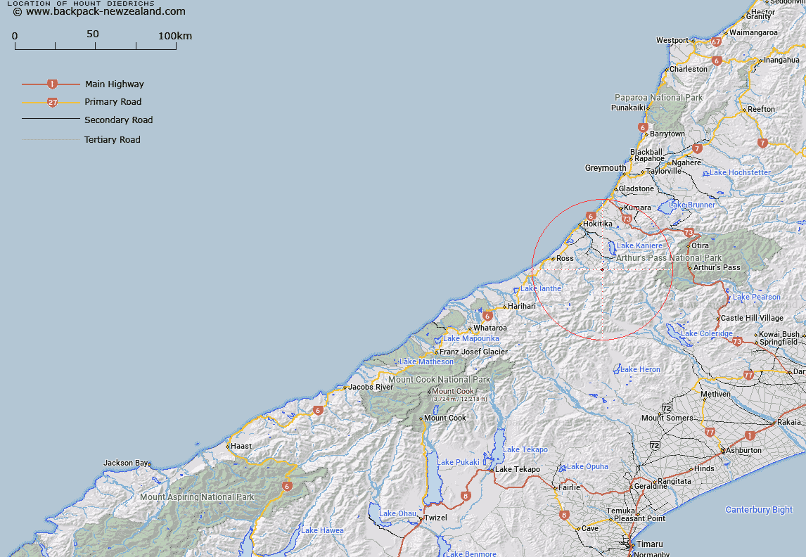
Map showing location of Mount Diedrichs


LINZ description: Mountain approximately 30 km south south east of Hokitika
Latitude: -42.951136
Longitude: 171.08734
Northing: 5242836.6
Easting: 1443976.6
Land District: Westland
Feat Type: Hill


Scroll down to see a more detailed road map and below that a topographical map showing the location of Mount Diedrichs. The road map has been supplied by openstreetmap and the topographical map of Mount Diedrichs has been supplied by Land Information New Zealand (LINZ).

Yes you can use the top static map for you school/university project or personal website with a link back. Contact me for any commercial use.

Mount Diedrichs Map New Zealand


New Zealand places in our database
[ A ] [ B ] [ C ] [ D ] [ E ] [ F ] [ G ] [ H ] [ I ] [ J ] [ K ] [ L ] [ M ] [ N ] [ O ] [ P ] [ Q ] [ R ] [ S ] [ T ] [ U ] [ V ] [ W ] [ X ] [ Y ] [ Z ]


Closest 20 Hills to Mount Diedrichs

Squall Peak ( 2.31km )   Jumble Top ( 2.36km )   Round Top ( 3.3km )   Mount O'Connor ( 4.98km )   Mount Robinson ( 5.06km )   Allan Knob ( 5.35km )   Mount Harry ( 6km )   Sam Knob ( 6.11km )   The Pinnacle ( 6.23km )   Frew Knob ( 6.59km )   Genoa Peak ( 6.92km )   Crinkle Top ( 7.41km )   Mount Ross ( 7.96km )   Mount Reeves ( 8.06km )   Mount Misery ( 8.48km )   Mount Inframeta ( 8.58km )   Mount Chamberlin ( 9.88km )   Mount Chamberlain ( 9.88km )   Mount Upright/Te Taumata o Uekanuku ( 9.98km )   Mount Upright ( 9.98km )   Mount Bannatyne ( 10.22km )   Bastion Ridge ( 10.62km )   Mount Browne ( 11.2km )   Mount Camelback ( 11.35km )   The Rampart ( 11.51km )   Doctor Hill ( 11.93km )   Mount Meta ( 12.2km )   Mount Graham ( 12.62km )   Tyndalls Knob ( 12.62km )   Mount Ambrose ( 13.3km )   Commodore Peak ( 13.62km )   Cairn Peak ( 13.7km )   Reef Knob ( 13.93km )   Conical Hill ( 14.37km )   Mount Park ( 14.44km )   Pigeon Hill ( 14.67km )   Mount Bowen ( 14.74km )   Sentinel Peak ( 14.91km )   Mount Harrison ( 14.92km )   Mount Kai Iwi ( 14.95km )