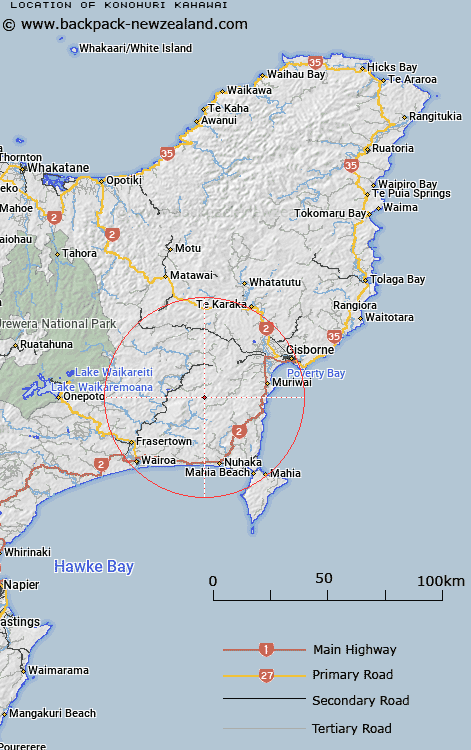
Map showing location of Konohuri Kahawai


LINZ description: Hill 634m high, 2km West of Paparitu hill, 4km North of the locality of Paparatu. Nuhaka North Survey District.
Latitude: -38.804089
Longitude: 177.684325
Northing: 5694528.6
Easting: 2006838.1
Land District: Gisborne
Feat Type: Locality


Scroll down to see a more detailed road map and below that a topographical map showing the location of Konohuri Kahawai. The road map has been supplied by openstreetmap and the topographical map of Konohuri Kahawai has been supplied by Land Information New Zealand (LINZ).

Yes you can use the top static map for you school/university project or personal website with a link back. Contact me for any commercial use.

Konohuri Kahawai Map New Zealand


New Zealand places in our database
[ A ] [ B ] [ C ] [ D ] [ E ] [ F ] [ G ] [ H ] [ I ] [ J ] [ K ] [ L ] [ M ] [ N ] [ O ] [ P ] [ Q ] [ R ] [ S ] [ T ] [ U ] [ V ] [ W ] [ X ] [ Y ] [ Z ]


Closest 20 Localitys to Konohuri Kahawai

Waingake ( 10.14km )   Tiniroto ( 10.76km )   Te Tahanga-o-te-konawhiti ( 11.07km )   Pahangaotekorowhiti ( 11.07km )   Rangikahikitia ( 11.24km )   Rangikaikitia ( 11.24km )   Tukemokihi ( 12.86km )   Tukemakihi ( 12.86km )   Te Reinga ( 14.17km )   Hangaroa ( 14.71km )   Waerengaokuri ( 14.96km )   Pehiri ( 18.56km )   Wharerata ( 18.79km )   Papakiateaio ( 20.03km )   Papakiateaia ( 20.03km )   Pukearia ( 20.41km )   Pukiaria ( 20.41km )   Poakahitia ( 20.66km )   Pouakahutia ( 20.66km )   Kaikauakaua ( 20.68km )   Taikawakawa ( 20.68km )   Mamaka ( 21.2km )   Mamaku ( 21.2km )   Anaotamaraukura ( 21.6km )   Te Ana Taumaraukura ( 21.6km )   Morere ( 21.7km )   Muriwai ( 21.78km )   Marumaru ( 22.36km )   Potara ( 22.62km )   Paotara ( 22.62km )   Waiwhero ( 22.9km )   Te Wai Wero ( 22.9km )   Otitangi ( 23.01km )   Otirangi ( 23.01km )   Manutuke ( 23.85km )   Te Rerengaotukiriahi ( 24.15km )   Ruakituri ( 24.39km )   Tahunga ( 24.68km )   Ngatapa ( 25.9km )   Tahaenui ( 26.09km )