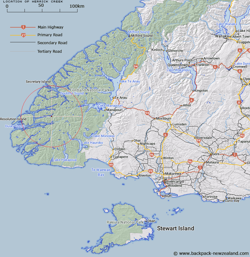
Map showing location of Herrick Creek


LINZ description: Stream at the southern side of Wet Jacket Arm, Dusky Sound, which enters the fiord 3.75km almost due east of Oke Island, flowing westward from 2km South-west of Tussock Peak.
Latitude: -45.636586
Longitude: 166.944421
Northing: 4928466.1
Easting: 1128061.9
Land District: Southland
Feat Type: Stream


Scroll down to see a more detailed road map and below that a topographical map showing the location of Herrick Creek. The road map has been supplied by openstreetmap and the topographical map of Herrick Creek has been supplied by Land Information New Zealand (LINZ).

Yes you can use the top static map for you school/university project or personal website with a link back. Contact me for any commercial use.

Herrick Creek Map New Zealand


New Zealand places in our database
[ A ] [ B ] [ C ] [ D ] [ E ] [ F ] [ G ] [ H ] [ I ] [ J ] [ K ] [ L ] [ M ] [ N ] [ O ] [ P ] [ Q ] [ R ] [ S ] [ T ] [ U ] [ V ] [ W ] [ X ] [ Y ] [ Z ]


Closest 20 Streams to Herrick Creek

Henry Burn ( 4.23km )   Hilda Burn ( 6.78km )   Macfarlane Stream ( 7.13km )   Bishop Burn ( 7.33km )   Kenneth Burn ( 9.7km )   Jane Burn ( 11.71km )   Roa Stream ( 11.94km )   Bessie Burn ( 12.26km )   Seaforth River ( 13.98km )   Kintail Stream ( 14.58km )   Deadwood Creek ( 15.24km )   Warren Burn ( 17.3km )   Occasional Cove ( 18.48km )   Hauroko Burn ( 18.57km )   Wynne Burn ( 18.59km )   Wynn Burn ( 18.59km )   Long Burn ( 18.72km )   Mike River ( 18.72km )   Waterfall Creek ( 19.15km )   Cockburn Stream ( 19.62km )   Gardner Burn ( 19.68km )   Lyvia River ( 20.51km )   Diamond Creek ( 21.38km )   Oho Creek ( 21.39km )   Coal River ( 21.43km )   Jacobs Creek ( 21.49km )   Bypass Stream ( 22.55km )   Takahe Stream ( 22.55km )   Emerald Stream ( 22.93km )   Florence Stream North Branch ( 22.96km )   Florence Stream ( 22.99km )   Shott Stream ( 23.05km )   Sholl Stream ( 23.05km )   Spey River ( 23.13km )   Dashwood Stream ( 23.42km )   Hay River ( 23.55km )   Left Hand Branch ( 24.2km )   Lumaluma Creek ( 24.2km )   Todd Burn ( 24.62km )   Stella Burn ( 24.78km )