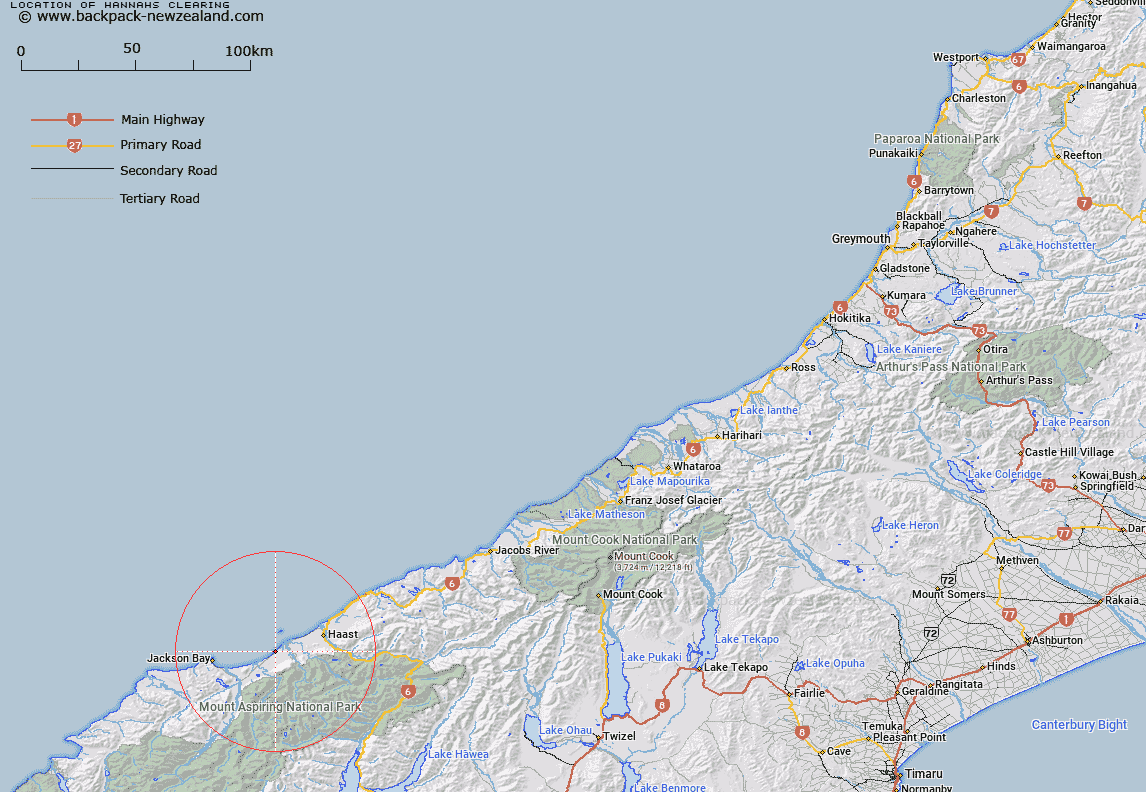
Map showing location of Hannahs Clearing


LINZ description: Locality south of Haast. Currently identified as Carters Mill on maps (22/02/1968 9:268)
Latitude: -43.941164
Longitude: 168.857926
Northing: 5126316.4
Easting: 1267573.9
Land District: Westland
Feat Type: Locality


Scroll down to see a more detailed road map and below that a topographical map showing the location of Hannahs Clearing. The road map has been supplied by openstreetmap and the topographical map of Hannahs Clearing has been supplied by Land Information New Zealand (LINZ).

Yes you can use the top static map for you school/university project or personal website with a link back. Contact me for any commercial use.

Hannahs Clearing Map New Zealand


New Zealand places in our database
[ A ] [ B ] [ C ] [ D ] [ E ] [ F ] [ G ] [ H ] [ I ] [ J ] [ K ] [ L ] [ M ] [ N ] [ O ] [ P ] [ Q ] [ R ] [ S ] [ T ] [ U ] [ V ] [ W ] [ X ] [ Y ] [ Z ]


Closest 20 Localitys to Hannahs Clearing

Okuru ( 5.1km )   Waiatoto ( 7.64km )   Arawhata ( 16.98km )   Neils Beach ( 17.12km )   Lake Moeraki ( 41.61km )   Makarora ( 44.11km )   Makarora Township ( 48.32km )   Lake Paringa ( 51.9km )   Minaret Bay ( 55.82km )   Maitahi ( 67.87km )   Mahitahi ( 67.87km )   Bruce Bay ( 69.61km )   Jacobs River ( 77.78km )   Lake Hawea ( 81.18km )   Lake H?wea ( 81.18km )   Gladstone ( 81.26km )   Jamestown ( 82.25km )   Glendhu Bay ( 82.43km )   Maungawera ( 84.24km )   Hawea Flat ( 86.17km )   H?wea Flat ( 86.17km )   Albert Town ( 86.61km )   Newcastle ( 86.61km )   Lower Hawea Flat ( 87.31km )   Lagoon Valley ( 89.08km )   Karangarua ( 90.54km )   Mount Barker ( 92.02km )   Bullendale (The Reefs) ( 95.33km )   Paradise ( 95.45km )   Luggate ( 95.48km )   Gillespies Beach ( 96.93km )   Rees Valley ( 98.79km )   Skippers ( 101.22km )   Birch Hill ( 101.86km )   Clearburn ( 102.64km )   Macetown ( 102.77km )   Charlestown ( 104.07km )   Lindis Valley ( 104.12km )   Cardrona ( 105.09km )   Omarama ( 106.37km )