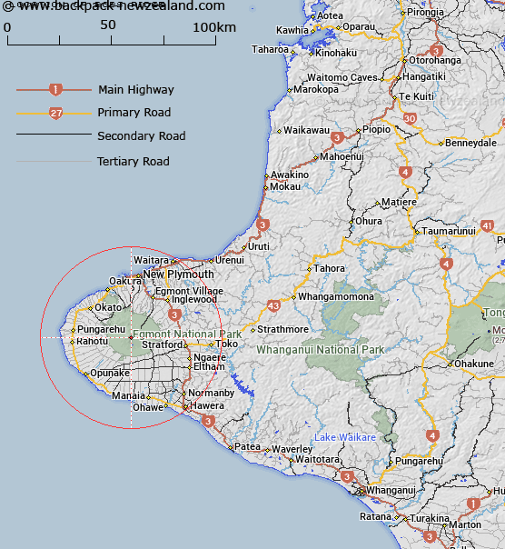
Map showing location of Bobs Ridge


LINZ description: Ridge 1.4km West of Fanthams Peak, Mount Egmont. Between Mangahume Stream and a tributary of the Waiaua River. Egmont Survey District.
Latitude: -39.307811
Longitude: 174.051426
Northing: 5648537.5
Easting: 1690650
Land District: Taranaki
Feat Type: Ridge


Scroll down to see a more detailed road map and below that a topographical map showing the location of Bobs Ridge. The road map has been supplied by openstreetmap and the topographical map of Bobs Ridge has been supplied by Land Information New Zealand (LINZ).

Yes you can use the top static map for you school/university project or personal website with a link back. Contact me for any commercial use.

Bobs Ridge Map New Zealand


New Zealand places in our database
[ A ] [ B ] [ C ] [ D ] [ E ] [ F ] [ G ] [ H ] [ I ] [ J ] [ K ] [ L ] [ M ] [ N ] [ O ] [ P ] [ Q ] [ R ] [ S ] [ T ] [ U ] [ V ] [ W ] [ X ] [ Y ] [ Z ]


Closest 20 Ridges to Bobs Ridge

Skeet Ridge ( 0.62km )   West Ridge ( 1.41km )   Mackay Rocks ( 1.61km )   Turtle ( 1.91km )   East Ridge ( 2.1km )   Lizard ( 2.12km )   Curtis Ridge ( 2.27km )   North Ridge ( 2.7km )   Carrington Ridge ( 3.4km )   The Puffer ( 3.93km )   The Razorback ( 4.01km )   Dover Spur ( 9.75km )   Titoki Ridge ( 56.57km )   Pinnacle Ridge ( 130.89km )   Waihohonu Ridge ( 132.06km )   Raepahu Ridge ( 143.75km )   Rogers Spur ( 155.22km )   Tower Ridge ( 161.97km )   Te Hiwiokaituri ( 163.49km )   The Pinnacles ( 169.24km )   Forks Spur ( 170.3km )   Taumata Ridge ( 173.46km )   Tin Kettle Spur ( 173.49km )   Pawerawera Ridge ( 175.48km )   The Paradise ( 176.68km )   Taurangatao Spur ( 178.55km )   Ohutu Ridge ( 180.67km )   Dirty Spur ( 181.78km )   The Hermitage ( 183.26km )   Papakiakuta Ridge ( 186.32km )   Wild Sheep Spur ( 187.13km )   Broken Ridge ( 188.03km )   Sawtooth Ridge ( 188.37km )   Daphne Ridge ( 189.67km )   Black Ridge ( 189.7km )   The Camelbacks ( 190.37km )   Totara Spur ( 190.41km )   Colenso Spur ( 190.48km )   Daphne Spur ( 190.69km )   Government Spur ( 191.73km )