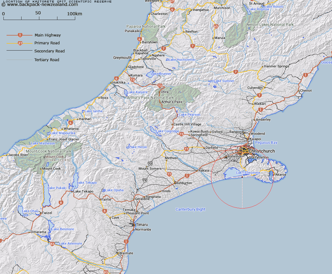
Map showing location of Kaitorete Spit Scientific Reserve


LINZ description: Sand and gravel barrier complex with extensive coastal sand dunes. Complex associations of sedgelands, herbfields and shrublands. Location: Coastal barrier between Te Waihora (Lake Ellesmere) and the Pacific Ocean, approximately 45km south of Christchurch.
Latitude: -43.830278
Longitude: 172.579167
Northing: 5146891.5
Easting: 1566164
Land District: Canterbury
Feat Type: Scientific Reserve


Scroll down to see a more detailed road map and below that a topographical map showing the location of Kaitorete Spit Scientific Reserve. The road map has been supplied by openstreetmap and the topographical map of Kaitorete Spit Scientific Reserve has been supplied by Land Information New Zealand (LINZ).

Yes you can use the top static map for you school/university project or personal website with a link back. Contact me for any commercial use.

Kaitorete Spit Scientific Reserve Map New Zealand


New Zealand places in our database
[ A ] [ B ] [ C ] [ D ] [ E ] [ F ] [ G ] [ H ] [ I ] [ J ] [ K ] [ L ] [ M ] [ N ] [ O ] [ P ] [ Q ] [ R ] [ S ] [ T ] [ U ] [ V ] [ W ] [ X ] [ Y ] [ Z ]


Closest 20 Scientific Reserves to Kaitorete Spit Scientific Reserve

Kaitorete Spit Scientific Reserve ( 0km )   Waihora Scientific Reserve ( 4.18km )   Bankside Scientific Reserve ( 35.44km )   Eyrewell Scientific Reserve ( 58.59km )   Enys Scientific Reserve ( 96.96km )   Medbury Scientific Reserve ( 108.24km )   Culverden Scientific Reserve ( 119.94km )   Lake Tekapo Scientific Reserve ( 169.64km )   Ianthe Scientific Reserve ( 183.12km )   Pukaki Scientific Reserve ( 199.44km )   Blue Duck Scientific Reserve ( 202.75km )   Bendhu Scientific Reserve ( 225.39km )   Shag Point Scientific Reserve ( 229.57km )   Shag Point/Matakaea Scientific Reserve ( 229.57km )   White Creek Fault Scientific Reserve ( 231.3km )   Chancet Rocks Scientific Reserve ( 258.07km )   Every's Scientific Reserve ( 273.19km )   Muritai Scientific Reserve ( 274.95km )   Lagoon Creek Scientific Reserve ( 275.11km )   Mata-au Scientific Reserve ( 278.26km )   Waiora Scientific Reserve ( 281.04km )   Locharburn Scientific Reserve ( 286.89km )   Mahaka Katia Scientific Reserve ( 289.81km )   Chapman Road Scientific Reserve ( 302.09km )   Black Rock Scientific Reserve ( 302.8km )   Kokorua Open Scientific Reserve ( 313.23km )   Sinclair Head Scientific Reserve ( 325.43km )   Red Rocks Scientific Reserve ( 326.31km )   Turakirae Head Scientific Reserve ( 328.97km )   Tom Shand Scientific Reserve ( 329.89km )   Lake Kohangapiripiri Wildlife Reserve ( 331.67km )   Lake Kohangatera and Lake Kohangapiripiri Scientific Reserve ( 331.67km )   Makaro Scientific Reserve ( 338.78km )   Matiu Scientific Reserve ( 341.87km )   Mokopuna Scientific Reserve ( 342.46km )   Taita Scientific Reserve ( 353.64km )   Otanomomo Scientific Reserve ( 353.71km )   Mana Island Scientific Reserve ( 354.4km )   Pukerua Bay Scientific Reserve ( 363.95km )   Pahaoa Scientific Reserve ( 371.5km )