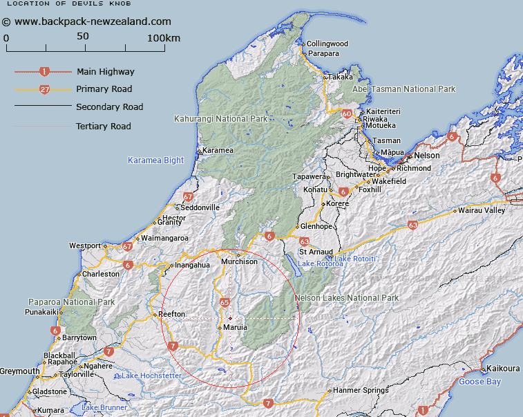
Map showing location of Devils Knob


LINZ description: Peak in Maruia State Forest at the headwaters of Thistle Creek, just south west of Granite Pinnacle.
Latitude: -42.135707
Longitude: 172.278869
Northing: 5334904.5
Easting: 1540404.5
Land District: Nelson
Feat Type: Hill


Scroll down to see a more detailed road map and below that a topographical map showing the location of Devils Knob. The road map has been supplied by openstreetmap and the topographical map of Devils Knob has been supplied by Land Information New Zealand (LINZ).

Yes you can use the top static map for you school/university project or personal website with a link back. Contact me for any commercial use.

Devils Knob Map New Zealand


New Zealand places in our database
[ A ] [ B ] [ C ] [ D ] [ E ] [ F ] [ G ] [ H ] [ I ] [ J ] [ K ] [ L ] [ M ] [ N ] [ O ] [ P ] [ Q ] [ R ] [ S ] [ T ] [ U ] [ V ] [ W ] [ X ] [ Y ] [ Z ]


Closest 20 Hills to Devils Knob

Granite Pinnacle ( 0.42km )   Mount Cann ( 4.73km )   Fyfe Peak ( 8.17km )   Creighton Peak ( 10.96km )   Mount Rutland ( 11.23km )   Mount Crosscut ( 12.37km )   Mount Oliver ( 12.97km )   Emily Peaks ( 13.35km )   Ivess Peak ( 15.18km )   Mount Ralph ( 16.55km )   Mount Maling ( 16.73km )   Baldy ( 16.96km )   Murty ( 17.26km )   Mount Mantell ( 17.41km )   Mount Burn ( 17.49km )   Baldy ( 17.7km )   Mount Victoria ( 17.78km )   Nardoo ( 18.11km )   Mount Blackadder ( 18.48km )   Hill Forty ( 19.7km )   Old Man of the Buller ( 20.64km )   O'Rourke ( 21.11km )   Mount Pelion ( 21.53km )   Mount Ossa ( 21.61km )   Kirwans Hill ( 21.94km )   Downie ( 22.34km )   Mailman ( 22.4km )   Crag ( 22.44km )   Gloriana Peak ( 22.48km )   Mount Albert ( 23.77km )   Faerie Queene Peak ( 24.13km )   Freyberg Peak ( 24.14km )   Marble Hill ( 24.69km )   Mount Magdalene ( 24.71km )   Mount Mueller ( 24.92km )   Mount Dorothy ( 25.22km )   Mount Ella ( 25.5km )   Mount Penneal ( 25.52km )   Mount Haast ( 25.62km )   Bourkes Rock ( 26.14km )