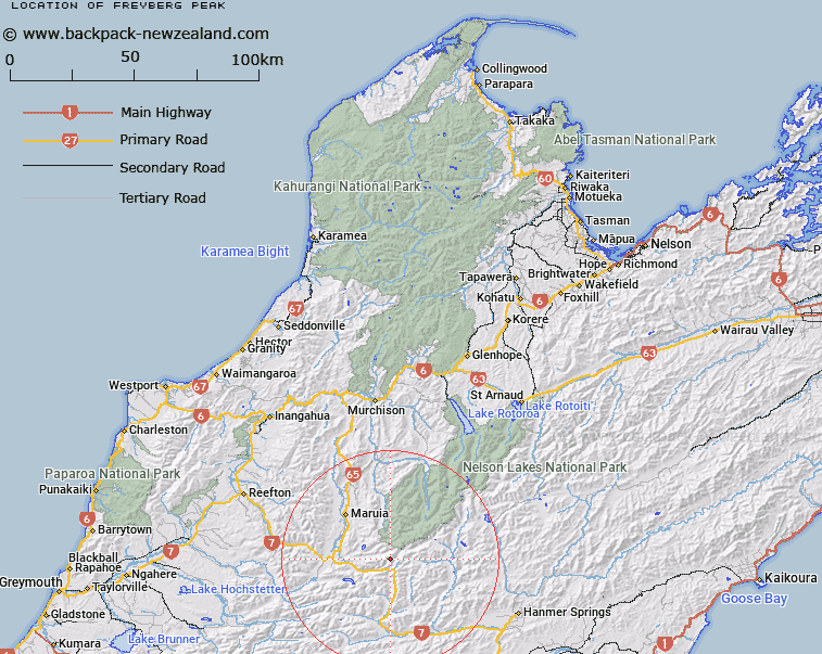
Map showing location of Freyberg Peak


LINZ description: Running north-east from Mount Mueller. Mount Freyberg is on this range
Latitude: -42.339872
Longitude: 172.378457
Northing: 5312300
Easting: 1548800
Land District: Nelson
Feat Type: Hill


Scroll down to see a more detailed road map and below that a topographical map showing the location of Freyberg Peak. The road map has been supplied by openstreetmap and the topographical map of Freyberg Peak has been supplied by Land Information New Zealand (LINZ).

Yes you can use the top static map for you school/university project or personal website with a link back. Contact me for any commercial use.

Freyberg Peak Map New Zealand


New Zealand places in our database
[ A ] [ B ] [ C ] [ D ] [ E ] [ F ] [ G ] [ H ] [ I ] [ J ] [ K ] [ L ] [ M ] [ N ] [ O ] [ P ] [ Q ] [ R ] [ S ] [ T ] [ U ] [ V ] [ W ] [ X ] [ Y ] [ Z ]


Closest 20 Hills to Freyberg Peak

Zampa ( 5.35km )   Trovatore ( 5.69km )   Travers Peak ( 7.04km )   Mount Mueller ( 7.1km )   The Apprentice ( 7.73km )   Mount Technical ( 7.9km )   Lucretia ( 8.44km )   Discovery Peak ( 8.88km )   Mount Esther ( 9.36km )   Norma ( 10.19km )   Philosophers Knob ( 10.79km )   Baldy ( 11.78km )   Mount Lucia ( 11.92km )   Gloriana Peak ( 12.16km )   The Grand Duchess ( 13.21km )   Rokeby ( 13.41km )   Mount Maling ( 13.57km )   Marble Hill ( 13.97km )   Hill Forty ( 13.98km )   Faerie Queene Peak ( 14.04km )   Mount Jervois ( 14.36km )   Mount Hatless ( 15.1km )   Mephistopheles ( 15.97km )   Maritana ( 16.28km )   Fyfe Peak ( 16.68km )   Faust ( 16.94km )   Martha ( 17.04km )   Mount Federation ( 17.24km )   Bunkers Hill ( 17.57km )   Mount Burn ( 17.85km )   Mount Scott ( 17.91km )   The Devils Rampart ( 18.08km )   Saint Mary ( 19.25km )   Mount Boscawen ( 19.38km )   Yanks Hill ( 19.79km )   Mount Carrington ( 20.15km )   Mount Moki ( 21.03km )   Mount Quail ( 21.07km )   Mount Alexander ( 21.12km )   Mount Maria ( 21.41km )