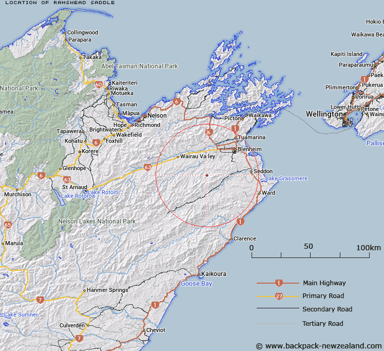
Map showing location of Ramshead Saddle


LINZ description: Saddle between the Omaka River and Dillion Creek, due west of Newport Knob.
Latitude: -41.69718
Longitude: 173.747593
Northing: 5383574.7
Easting: 1662206.7
Land District: Marlborough
Feat Type: Pass


Scroll down to see a more detailed road map and below that a topographical map showing the location of Ramshead Saddle. The road map has been supplied by openstreetmap and the topographical map of Ramshead Saddle has been supplied by Land Information New Zealand (LINZ).

Yes you can use the top static map for you school/university project or personal website with a link back. Contact me for any commercial use.

Ramshead Saddle Map New Zealand


New Zealand places in our database
[ A ] [ B ] [ C ] [ D ] [ E ] [ F ] [ G ] [ H ] [ I ] [ J ] [ K ] [ L ] [ M ] [ N ] [ O ] [ P ] [ Q ] [ R ] [ S ] [ T ] [ U ] [ V ] [ W ] [ X ] [ Y ] [ Z ]


Closest 20 Passs to Ramshead Saddle

Pig Whare Saddle ( 4.64km )   Blairich Pass ( 6.03km )   Catsears Saddle ( 6.73km )   Taylor Pass ( 19.5km )   Tomlinsons Saddle ( 19.94km )   Tomahawk Saddle ( 20.02km )   Sweets Saddle ( 20.71km )   Avon Saddle ( 23.2km )   Skippers Saddle ( 23.86km )   Medway Saddle ( 24.1km )   Maxwell Pass ( 24.65km )   Dashwood Pass ( 27.2km )   Weld Pass ( 27.32km )   Redwood Pass ( 29.05km )   Burnt Saddle ( 31.36km )   Mosses Dip ( 31.5km )   Chaytors Saddle ( 31.98km )   Upcot Saddle ( 32.51km )   Rag Saddle ( 33.5km )   Beehive Saddle ( 33.72km )   Richmond Saddle ( 39.2km )   Totara Saddle ( 40.62km )   Calf Saddle ( 40.78km )   Cuckoo Saddle ( 41.14km )   George Saddle ( 45.37km )   Acheron Saddle ( 45.47km )   Haycock Saddle ( 47.63km )   Port Cooper Saddle ( 48.36km )   Weka Saddle ( 48.47km )   Lowther Saddle ( 48.48km )   T?tara Saddle ( 49.75km )   Dun Saddle ( 50.19km )   Waihopai Saddle ( 50.55km )   Coppermine Saddle ( 50.82km )   Maungatapu Saddle ( 51.56km )   Saxton Saddle ( 52.99km )   Wards Pass ( 53.61km )   Kaiuma Saddle ( 55.14km )   Tantragee Saddle ( 57.91km )   Tone Saddle ( 57.94km )