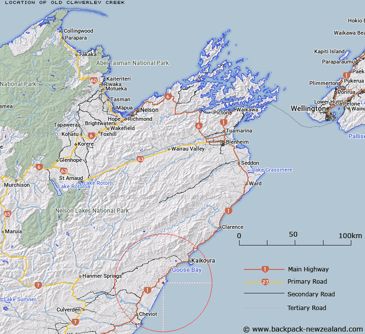
Map showing location of Old Claverley Creek


LINZ description: Rises under Barking Dog Hill and flows out to coast south of Spy Glass Point (Piripaua)
Latitude: -42.5728
Longitude: 173.48265
Northing: 5286510.4
Easting: 1639611.4
Land District: Marlborough
Feat Type: Stream


Scroll down to see a more detailed road map and below that a topographical map showing the location of Old Claverley Creek. The road map has been supplied by openstreetmap and the topographical map of Old Claverley Creek has been supplied by Land Information New Zealand (LINZ).

Yes you can use the top static map for you school/university project or personal website with a link back. Contact me for any commercial use.

Old Claverley Creek Map New Zealand


New Zealand places in our database
[ A ] [ B ] [ C ] [ D ] [ E ] [ F ] [ G ] [ H ] [ I ] [ J ] [ K ] [ L ] [ M ] [ N ] [ O ] [ P ] [ Q ] [ R ] [ S ] [ T ] [ U ] [ V ] [ W ] [ X ] [ Y ] [ Z ]


Closest 20 Streams to Old Claverley Creek

Waitotaranui Creek ( 1.2km )   Okarahia Stream ( 2.68km )   Limestone Stream ( 3.01km )   Mikonui Stream ( 3.97km )   Derek Stream ( 4.19km )   Stocker Stream ( 4.52km )   Te Kahika Stream ( 5.02km )   Hundalee Stream ( 5.42km )   Kaka Mutu Stream ( 6.12km )   Te Moto Moto Stream ( 6.44km )   Weatherhill Stream ( 6.8km )   Silvery Creek ( 7.83km )   Open Creek ( 8.31km )   Oaro River ( 9.23km )   Omihi Stream ( 9.44km )   Sawpit Creek ( 9.57km )   Mick Stream ( 9.84km )   Ploughman Creek ( 9.89km )   Blackburn Stream ( 9.94km )   Glen Colwyn Stream ( 10.26km )   Boundary Stream ( 10.65km )   Birthday Creek ( 10.75km )   Hewsons Stream ( 10.91km )   Rocky Creek ( 11.21km )   Ote Makura Stream ( 11.32km )   Sebastopol Creek ( 11.52km )   Spey Stream ( 12.49km )   Dawn Creek ( 12.74km )   Kie Kie Stream ( 13.65km )   Ngaroma Stream ( 13.79km )   Stag Stream ( 13.89km )   Rosy Morn Stream ( 14.42km )   Fern Flat Stream ( 14.47km )   Chilly Stream ( 14.85km )   Waingaro Stream ( 14.91km )   Wairere Stream ( 15.3km )   Inverness Stream ( 15.39km )   Charwell River ( 15.82km )   Hawkswood Stream ( 15.84km )   Rutherford Stream ( 16.12km )