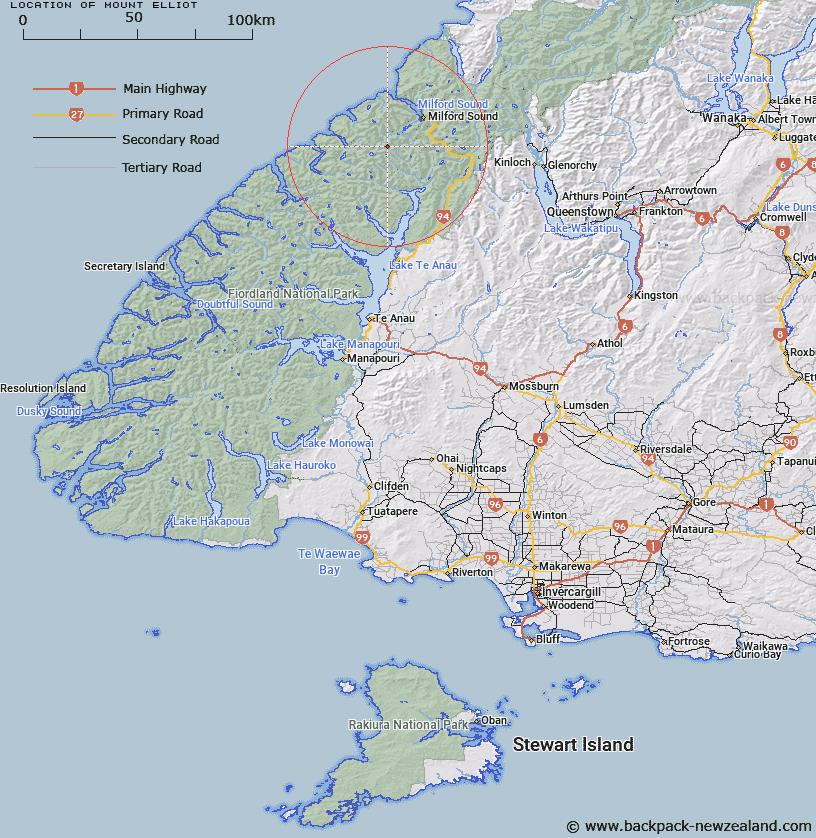
Map showing location of Mount Elliot


LINZ description: Peak on north side of Jervois Glacier, it is a prominent feature on the Milford Track after crossing the Mackinnon pass on the way to Quinton Huts.
Latitude: -44.779758
Longitude: 167.784992
Northing: 5028270.4
Easting: 1187401.4
Land District: Southland
Feat Type: Hill


Scroll down to see a more detailed road map and below that a topographical map showing the location of Mount Elliot. The road map has been supplied by openstreetmap and the topographical map of Mount Elliot has been supplied by Land Information New Zealand (LINZ).

Yes you can use the top static map for you school/university project or personal website with a link back. Contact me for any commercial use.

Mount Elliot Map New Zealand


New Zealand places in our database
[ A ] [ B ] [ C ] [ D ] [ E ] [ F ] [ G ] [ H ] [ I ] [ J ] [ K ] [ L ] [ M ] [ N ] [ O ] [ P ] [ Q ] [ R ] [ S ] [ T ] [ U ] [ V ] [ W ] [ X ] [ Y ] [ Z ]


Closest 20 Hills to Mount Elliot

Mount Wilmur ( 1.11km )   Mount Kepka ( 1.97km )   Mount Balloon ( 2.26km )   Dumpling Hill ( 3.04km )   Mount Pillans ( 3.63km )   Mount Hart ( 4.23km )   Aiguille Rouge ( 4.56km )   Mount Daniel ( 5.27km )   Mount Edgar ( 6.19km )   Twin Sisters ( 7.02km )   Couloir Peak ( 7.09km )   Mount Mackenzie ( 7.12km )   Steep Hill ( 7.48km )   Castle Mount ( 7.56km )   Pariroa / Castle Mount ( 7.56km )   Lady of the Snows ( 7.87km )   Mount Fisher ( 8.57km )   Mount Mitchelson ( 8.68km )   Danger Mount ( 9.17km )   Barrier Peak ( 9.22km )   Shoulder Hill ( 9.23km )   Mount Danger ( 9.61km )   Mount Ada ( 9.79km )   Lloyd Peak ( 10.39km )   Basin Peak ( 11.28km )   Access Peak ( 11.41km )   Odyssey Peak ( 11.46km )   Terror Peak ( 12.07km )   Mount Gendarme ( 12.67km )   Devils Armchair ( 12.71km )   Rugged Mountain ( 13.9km )   Cirque Peak ( 14.19km )   Gulliver Peak ( 14.37km )   Mount Anau ( 14.42km )   Mount Phillips ( 14.73km )   Mount Philipps ( 14.73km )   Mount Isolation ( 14.77km )   Sheerdown Peak ( 15.1km )   Mount Moir ( 15.18km )   Mount McPherson ( 15.46km )