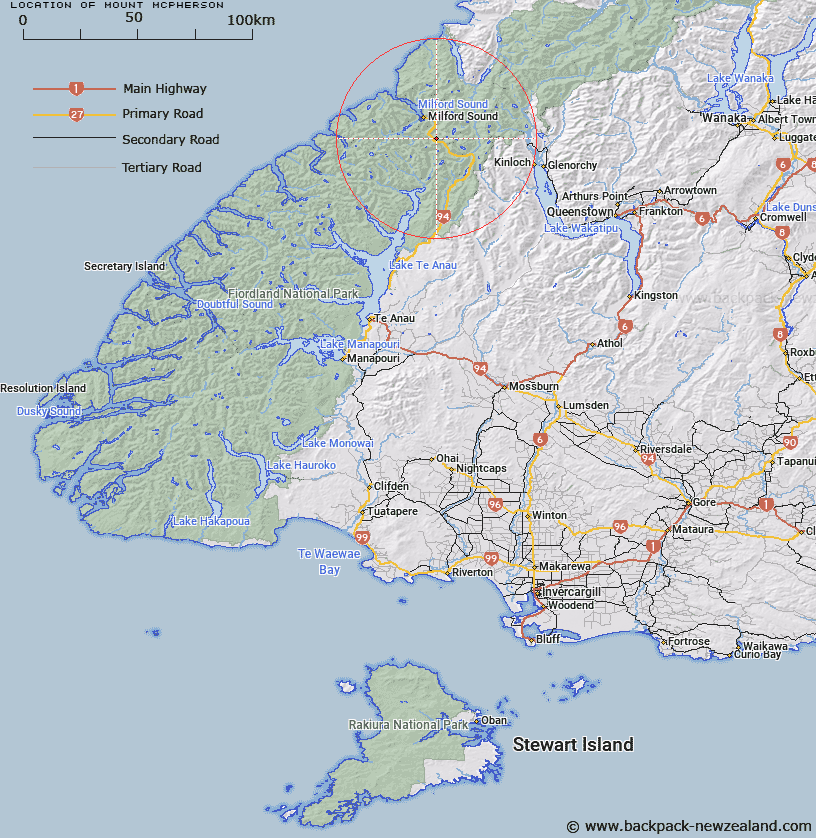
Map showing location of Mount McPherson


LINZ description: Peak due north of Homer Tunnel
Latitude: -44.748459
Longitude: 167.975799
Northing: 5032700
Easting: 1202282.6
Land District: Southland
Feat Type: Hill


Scroll down to see a more detailed road map and below that a topographical map showing the location of Mount McPherson. The road map has been supplied by openstreetmap and the topographical map of Mount McPherson has been supplied by Land Information New Zealand (LINZ).

Yes you can use the top static map for you school/university project or personal website with a link back. Contact me for any commercial use.

Mount McPherson Map New Zealand


New Zealand places in our database
[ A ] [ B ] [ C ] [ D ] [ E ] [ F ] [ G ] [ H ] [ I ] [ J ] [ K ] [ L ] [ M ] [ N ] [ O ] [ P ] [ Q ] [ R ] [ S ] [ T ] [ U ] [ V ] [ W ] [ X ] [ Y ] [ Z ]


Closest 20 Hills to Mount McPherson

Mount Lippe ( 1.73km )   Mount Talbot ( 1.73km )   Cockburn Incline ( 2.24km )   Mount Isolation ( 2.38km )   Mount Moir ( 2.69km )   Gulliver Peak ( 2.84km )   Mount Belle ( 2.97km )   Barrier Knob ( 3.9km )   Cirque Peak ( 4.06km )   The Sentinel ( 4.61km )   Barrier Peak ( 4.75km )   West Peak ( 4.77km )   Mount Gendarme ( 4.78km )   The Twins ( 4.88km )   Access Peak ( 4.93km )   Middle Peak ( 5.03km )   Students Peak ( 5.23km )   Second Peak ( 5.25km )   Lloyd Peak ( 5.39km )   East Peak ( 5.44km )   Marian Peak ( 5.51km )   Mihj Peak ( 5.75km )   Basin Peak ( 5.97km )   Sabre Peak ( 6.05km )   Sheerdown Peak ( 6.21km )   Adelaide Peak ( 6.54km )   Mount Park ( 6.72km )   Low Peak ( 6.83km )   North Peak ( 6.86km )   Third Peak ( 7.13km )   Odyssey Peak ( 7.15km )   South Peak ( 7.4km )   Apirana Peak ( 7.51km )   Mount Ada ( 7.54km )   Mount Christina ( 7.6km )   High Peak ( 7.62km )   Mount Gifford ( 8.25km )   Mount Suter ( 8.32km )   Mount Gunn ( 8.57km )   East Peak ( 8.59km )